You are here: Home > Network List > TA - USArray Transportable Network (new EarthScope stations) Stations List
> Station R11A Troy Canyon, Currant, NV, USA > Earthquake Result Viewer
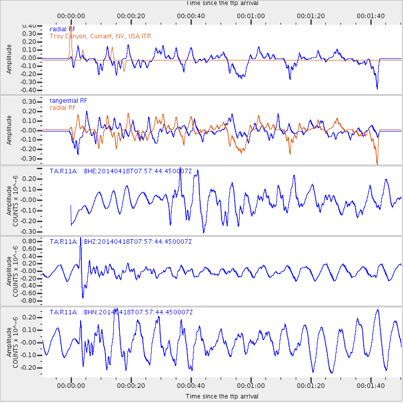
R11A Troy Canyon, Currant, NV, USA - Earthquake Result Viewer
*The percent match for this event was below the threshold and hence no stack was calculated.
| Earthquake location: |
Santiago Del Estero Prov., Arg. |
| Earthquake latitude/longitude: |
-27.7/-62.8 |
| Earthquake time(UTC): |
2014/04/18 (108) 07:46:57 GMT |
| Earthquake Depth: |
610 km |
| Earthquake Magnitude: |
5.6 MW |
| Earthquake Catalog/Contributor: |
ISC/ISC |
|
| Network: |
TA USArray Transportable Network (new EarthScope stations) |
| Station: |
R11A Troy Canyon, Currant, NV, USA |
| Lat/Lon: |
38.35 N/115.59 W |
| Elevation: |
1756 m |
|
| Distance: |
82.2 deg |
| Az: |
320.809 deg |
| Baz: |
134.57 deg |
| Ray Param: |
$rayparam |
*The percent match for this event was below the threshold and hence was not used in the summary stack. |
|
| Radial Match: |
41.90581 % |
| Radial Bump: |
400 |
| Transverse Match: |
48.299694 % |
| Transverse Bump: |
400 |
| SOD ConfigId: |
3390531 |
| Insert Time: |
2019-04-11 11:01:00.810 +0000 |
| GWidth: |
2.5 |
| Max Bumps: |
400 |
| Tol: |
0.001 |
|
Signal To Noise
| Channel | StoN | STA | LTA |
| TA:R11A: :BHZ:20140418T07:57:44.450007Z | 3.3701599 | 3.4834213E-7 | 1.0336071E-7 |
| TA:R11A: :BHN:20140418T07:57:44.450007Z | 0.85439855 | 7.414926E-8 | 8.6785334E-8 |
| TA:R11A: :BHE:20140418T07:57:44.450007Z | 0.9333306 | 7.971982E-8 | 8.541434E-8 |
| Arrivals |
| Ps | |
| PpPs | |
| PsPs/PpSs | |


