You are here: Home > Network List > G - GEOSCOPE Stations List
> Station HYB Hyderabad, India > Earthquake Result Viewer
HYB Hyderabad, India - Earthquake Result Viewer

| Earthquake location: |
Flores Sea |
| Earthquake latitude/longitude: |
-7.3/122.6 |
| Earthquake time(UTC): |
1991/06/07 (158) 11:51:27 GMT |
| Earthquake Depth: |
563 km |
| Earthquake Magnitude: |
6.3 MB |
| Earthquake Catalog/Contributor: |
WHDF/NEIC |
|
| Network: |
G GEOSCOPE |
| Station: |
HYB Hyderabad, India |
| Lat/Lon: |
17.42 N/78.55 E |
| Elevation: |
510 m |
|
| Distance: |
49.9 deg |
| Az: |
299.899 deg |
| Baz: |
115.734 deg |
| Ray Param: |
0.06579587 |
| Estimated Moho Depth: |
33.0 km |
| Estimated Crust Vp/Vs: |
1.74 |
| Assumed Crust Vp: |
6.459 km/s |
| Estimated Crust Vs: |
3.712 km/s |
| Estimated Crust Poisson's Ratio: |
0.25 |
|
| Radial Match: |
94.80316 % |
| Radial Bump: |
342 |
| Transverse Match: |
85.46475 % |
| Transverse Bump: |
400 |
| SOD ConfigId: |
4480 |
| Insert Time: |
2010-02-26 22:46:14.624 +0000 |
| GWidth: |
2.5 |
| Max Bumps: |
400 |
| Tol: |
0.001 |
|
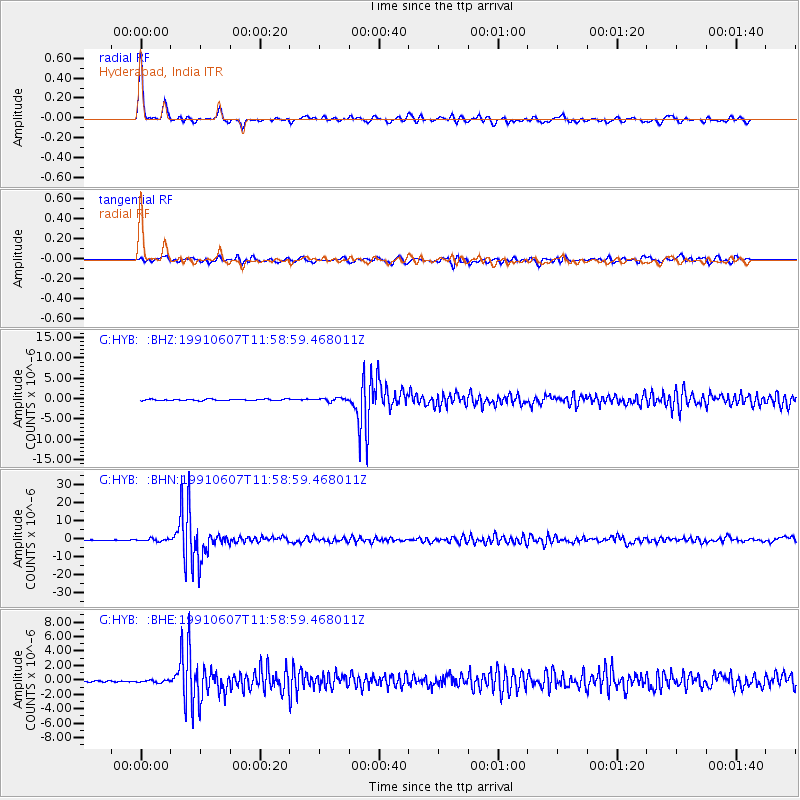
Signal To Noise
| Channel | StoN | STA | LTA |
| G:HYB: :BHN:19910607T11:58:59.468011Z | 2.3482823 | 7.0394907E-7 | 2.9977193E-7 |
| G:HYB: :BHE:19910607T11:58:59.468011Z | 0.97219604 | 1.7038636E-7 | 1.7525926E-7 |
| G:HYB: :BHZ:19910607T11:58:59.468011Z | 2.3175292 | 3.8995165E-7 | 1.682618E-7 |
| Arrivals |
| Ps | 4.0 SECOND |
| PpPs | 13 SECOND |
| PsPs/PpSs | 17 SECOND |


