You are here: Home > Network List > IU - Global Seismograph Network (GSN - IRIS/USGS) Stations List
> Station XMAS Kiritimati Island, Republic of Kiribati > Earthquake Result Viewer
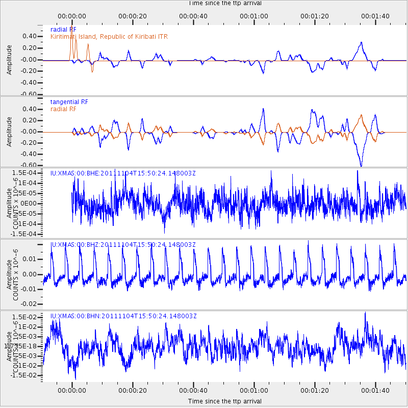
XMAS Kiritimati Island, Republic of Kiribati - Earthquake Result Viewer
*The percent match for this event was below the threshold and hence no stack was calculated.
| Earthquake location: |
Vanuatu Islands |
| Earthquake latitude/longitude: |
-15.1/167.4 |
| Earthquake time(UTC): |
2011/11/04 (308) 15:43:43 GMT |
| Earthquake Depth: |
134 km |
| Earthquake Magnitude: |
5.6 MB, 5.8 MW, 5.8 MW |
| Earthquake Catalog/Contributor: |
WHDF/NEIC |
|
| Network: |
IU Global Seismograph Network (GSN - IRIS/USGS) |
| Station: |
XMAS Kiritimati Island, Republic of Kiribati |
| Lat/Lon: |
2.04 N/157.45 W |
| Elevation: |
20 m |
|
| Distance: |
38.7 deg |
| Az: |
66.891 deg |
| Baz: |
242.747 deg |
| Ray Param: |
$rayparam |
*The percent match for this event was below the threshold and hence was not used in the summary stack. |
|
| Radial Match: |
39.777954 % |
| Radial Bump: |
400 |
| Transverse Match: |
39.637527 % |
| Transverse Bump: |
400 |
| SOD ConfigId: |
424168 |
| Insert Time: |
2012-02-17 14:30:19.553 +0000 |
| GWidth: |
2.5 |
| Max Bumps: |
400 |
| Tol: |
0.001 |
|
Signal To Noise
| Channel | StoN | STA | LTA |
| IU:XMAS:00:BHZ:20111104T15:50:24.148003Z | 0.9707521 | 6.7418773E-9 | 6.945004E-9 |
| IU:XMAS:00:BHN:20111104T15:50:24.148003Z | 1.1014051 | 7.811406E-9 | 7.0922184E-9 |
| IU:XMAS:00:BHE:20111104T15:50:24.148003Z | 1.1832991 | 5.4919114E-11 | 4.6411864E-11 |
| Arrivals |
| Ps | |
| PpPs | |
| PsPs/PpSs | |


