You are here: Home > Network List > AU - Australian Seismological Centre Stations List
> Station WRKA Warrakurna, Western Australia > Earthquake Result Viewer
WRKA Warrakurna, Western Australia - Earthquake Result Viewer
| Earthquake location: |
Vanuatu Islands |
| Earthquake latitude/longitude: |
-18.2/168.3 |
| Earthquake time(UTC): |
2011/11/05 (309) 01:49:18 GMT |
| Earthquake Depth: |
35 km |
| Earthquake Magnitude: |
5.8 MB, 5.5 MS, 5.9 MW, 5.8 MW |
| Earthquake Catalog/Contributor: |
WHDF/NEIC |
|
| Network: |
AU Australian Seismological Centre |
| Station: |
WRKA Warrakurna, Western Australia |
| Lat/Lon: |
25.04 S/128.30 E |
| Elevation: |
622 m |
|
| Distance: |
37.7 deg |
| Az: |
252.506 deg |
| Baz: |
87.738 deg |
| Ray Param: |
0.075921565 |
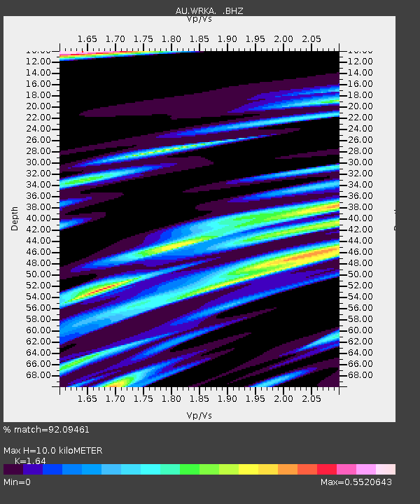
| Estimated Moho Depth: |
10.0 km |
| Estimated Crust Vp/Vs: |
1.64 |
| Assumed Crust Vp: |
6.51 km/s |
| Estimated Crust Vs: |
3.97 km/s |
| Estimated Crust Poisson's Ratio: |
0.20 |
|
| Radial Match: |
92.09461 % |
| Radial Bump: |
295 |
| Transverse Match: |
71.61634 % |
| Transverse Bump: |
400 |
| SOD ConfigId: |
424168 |
| Insert Time: |
2012-02-24 04:30:07.307 +0000 |
| GWidth: |
2.5 |
| Max Bumps: |
400 |
| Tol: |
0.001 |
|

Signal To Noise
| Channel | StoN | STA | LTA |
| AU:WRKA: :BHZ:20111105T01:56:00.670002Z | 3.1057982 | 4.3358364E-7 | 1.3960458E-7 |
| AU:WRKA: :BHN:20111105T01:56:00.670002Z | 0.8019593 | 7.915505E-8 | 9.870208E-8 |
| AU:WRKA: :BHE:20111105T01:56:00.670002Z | 4.289207 | 3.0794564E-7 | 7.1795476E-8 |
| Arrivals |
| Ps | 1.1 SECOND |
| PpPs | 3.7 SECOND |
| PsPs/PpSs | 4.8 SECOND |


