You are here: Home > Network List > TA - USArray Transportable Network (new EarthScope stations) Stations List
> Station J05D Fort Rock, OR, USA > Earthquake Result Viewer
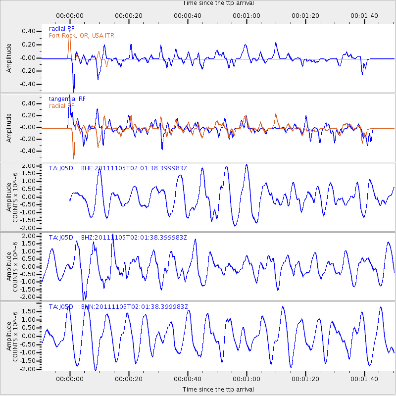
J05D Fort Rock, OR, USA - Earthquake Result Viewer
*The percent match for this event was below the threshold and hence no stack was calculated.
| Earthquake location: |
Vanuatu Islands |
| Earthquake latitude/longitude: |
-18.2/168.3 |
| Earthquake time(UTC): |
2011/11/05 (309) 01:49:18 GMT |
| Earthquake Depth: |
35 km |
| Earthquake Magnitude: |
5.8 MB, 5.5 MS, 5.9 MW, 5.8 MW |
| Earthquake Catalog/Contributor: |
WHDF/NEIC |
|
| Network: |
TA USArray Transportable Network (new EarthScope stations) |
| Station: |
J05D Fort Rock, OR, USA |
| Lat/Lon: |
43.28 N/121.23 W |
| Elevation: |
1541 m |
|
| Distance: |
88.9 deg |
| Az: |
43.498 deg |
| Baz: |
243.613 deg |
| Ray Param: |
$rayparam |
*The percent match for this event was below the threshold and hence was not used in the summary stack. |
|
| Radial Match: |
53.45926 % |
| Radial Bump: |
400 |
| Transverse Match: |
66.71074 % |
| Transverse Bump: |
400 |
| SOD ConfigId: |
424168 |
| Insert Time: |
2012-02-24 04:35:01.261 +0000 |
| GWidth: |
2.5 |
| Max Bumps: |
400 |
| Tol: |
0.001 |
|
Signal To Noise
| Channel | StoN | STA | LTA |
| TA:J05D: :BHZ:20111105T02:01:38.399983Z | 2.1421185 | 1.0083636E-6 | 4.7073198E-7 |
| TA:J05D: :BHN:20111105T02:01:38.399983Z | 3.2657604 | 1.272503E-6 | 3.8964984E-7 |
| TA:J05D: :BHE:20111105T02:01:38.399983Z | 1.0551877 | 6.9693255E-7 | 6.6048204E-7 |
| Arrivals |
| Ps | |
| PpPs | |
| PsPs/PpSs | |


