You are here: Home > Network List > G - GEOSCOPE Stations List
> Station HYB Hyderabad, India > Earthquake Result Viewer
HYB Hyderabad, India - Earthquake Result Viewer
| Earthquake location: |
Minahassa Peninsula, Sulawesi |
| Earthquake latitude/longitude: |
1.1/124.0 |
| Earthquake time(UTC): |
1990/12/13 (347) 12:26:40 GMT |
| Earthquake Depth: |
33 km |
| Earthquake Magnitude: |
6.0 MB, 5.7 MS, 5.5 UNKNOWN |
| Earthquake Catalog/Contributor: |
WHDF/NEIC |
|
| Network: |
G GEOSCOPE |
| Station: |
HYB Hyderabad, India |
| Lat/Lon: |
17.42 N/78.55 E |
| Elevation: |
510 m |
|
| Distance: |
47.5 deg |
| Az: |
292.7 deg |
| Baz: |
104.959 deg |
| Ray Param: |
0.069891214 |
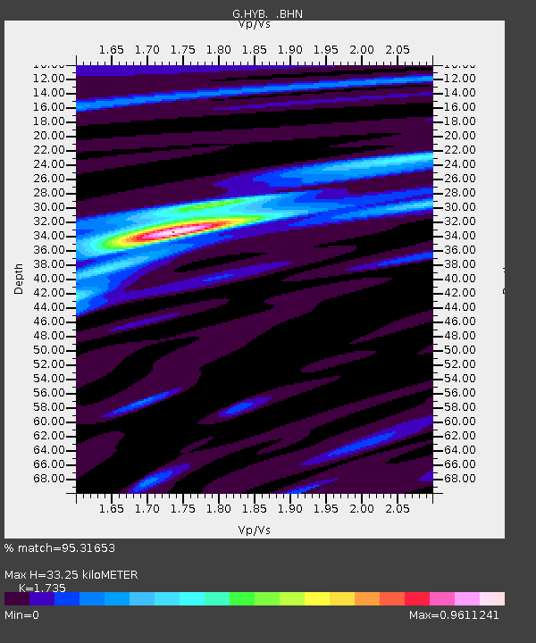
| Estimated Moho Depth: |
33.25 km |
| Estimated Crust Vp/Vs: |
1.74 |
| Assumed Crust Vp: |
6.459 km/s |
| Estimated Crust Vs: |
3.723 km/s |
| Estimated Crust Poisson's Ratio: |
0.25 |
|
| Radial Match: |
95.31653 % |
| Radial Bump: |
276 |
| Transverse Match: |
77.646225 % |
| Transverse Bump: |
400 |
| SOD ConfigId: |
16938 |
| Insert Time: |
2010-02-26 22:46:33.951 +0000 |
| GWidth: |
2.5 |
| Max Bumps: |
400 |
| Tol: |
0.001 |
|

Signal To Noise
| Channel | StoN | STA | LTA |
| G:HYB: :BHN:19901213T12:34:41.750Z | 2.6270626 | 1.5638477E-7 | 5.952838E-8 |
| G:HYB: :BHE:19901213T12:34:41.750Z | 8.385068 | 4.4766736E-7 | 5.3388643E-8 |
| G:HYB: :BHZ:19901213T12:34:41.750Z | 14.081085 | 9.181811E-7 | 6.52067E-8 |
| Arrivals |
| Ps | 4.0 SECOND |
| PpPs | 13 SECOND |
| PsPs/PpSs | 17 SECOND |


