You are here: Home > Network List > TA - USArray Transportable Network (new EarthScope stations) Stations List
> Station J04D Umpqua National Forest, Toketee, OR, USA > Earthquake Result Viewer
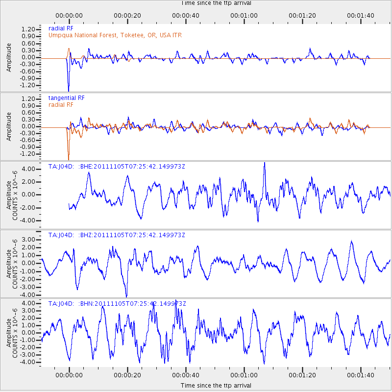
J04D Umpqua National Forest, Toketee, OR, USA - Earthquake Result Viewer
*The percent match for this event was below the threshold and hence no stack was calculated.
| Earthquake location: |
Near Coast Of Northern Chile |
| Earthquake latitude/longitude: |
-23.5/-70.2 |
| Earthquake time(UTC): |
2011/11/05 (309) 07:13:57 GMT |
| Earthquake Depth: |
33 km |
| Earthquake Magnitude: |
5.9 MB, 5.2 MS, 5.7 MW, 5.7 MW |
| Earthquake Catalog/Contributor: |
WHDF/NEIC |
|
| Network: |
TA USArray Transportable Network (new EarthScope stations) |
| Station: |
J04D Umpqua National Forest, Toketee, OR, USA |
| Lat/Lon: |
43.24 N/122.11 W |
| Elevation: |
1948 m |
|
| Distance: |
81.7 deg |
| Az: |
324.466 deg |
| Baz: |
133.09 deg |
| Ray Param: |
$rayparam |
*The percent match for this event was below the threshold and hence was not used in the summary stack. |
|
| Radial Match: |
57.55637 % |
| Radial Bump: |
400 |
| Transverse Match: |
36.673336 % |
| Transverse Bump: |
400 |
| SOD ConfigId: |
424168 |
| Insert Time: |
2012-02-24 04:45:42.518 +0000 |
| GWidth: |
2.5 |
| Max Bumps: |
400 |
| Tol: |
0.001 |
|
Signal To Noise
| Channel | StoN | STA | LTA |
| TA:J04D: :BHZ:20111105T07:25:42.149973Z | 1.507426 | 1.5482077E-6 | 1.0270538E-6 |
| TA:J04D: :BHN:20111105T07:25:42.149973Z | 0.7776759 | 1.887703E-6 | 2.4273647E-6 |
| TA:J04D: :BHE:20111105T07:25:42.149973Z | 1.0183909 | 1.5494534E-6 | 1.5214722E-6 |
| Arrivals |
| Ps | |
| PpPs | |
| PsPs/PpSs | |


