You are here: Home > Network List > CI - Caltech Regional Seismic Network Stations List
> Station MPM Manuel Prospect Mine, California, USA > Earthquake Result Viewer
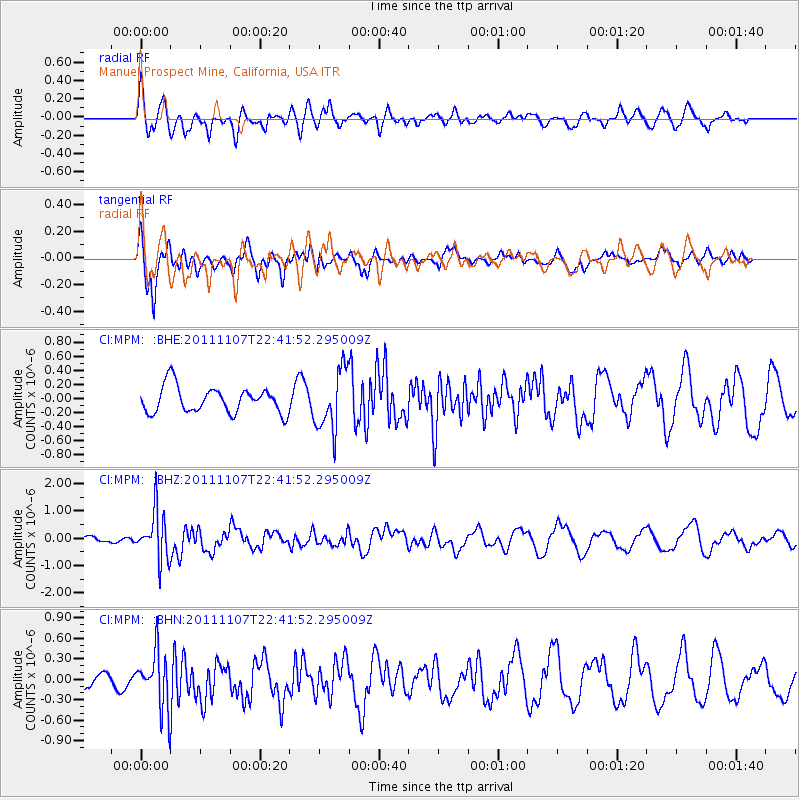
MPM Manuel Prospect Mine, California, USA - Earthquake Result Viewer
*The percent match for this event was below the threshold and hence no stack was calculated.
| Earthquake location: |
Nicaragua |
| Earthquake latitude/longitude: |
11.6/-85.9 |
| Earthquake time(UTC): |
2011/11/07 (311) 22:35:25 GMT |
| Earthquake Depth: |
177 km |
| Earthquake Magnitude: |
6.0 MB, 6.0 MW, 6.1 MW |
| Earthquake Catalog/Contributor: |
WHDF/NEIC |
|
| Network: |
CI Caltech Regional Seismic Network |
| Station: |
MPM Manuel Prospect Mine, California, USA |
| Lat/Lon: |
36.06 N/117.49 W |
| Elevation: |
185 m |
|
| Distance: |
37.6 deg |
| Az: |
315.797 deg |
| Baz: |
122.521 deg |
| Ray Param: |
$rayparam |
*The percent match for this event was below the threshold and hence was not used in the summary stack. |
|
| Radial Match: |
66.52452 % |
| Radial Bump: |
400 |
| Transverse Match: |
75.356 % |
| Transverse Bump: |
400 |
| SOD ConfigId: |
424168 |
| Insert Time: |
2012-02-24 05:28:34.707 +0000 |
| GWidth: |
2.5 |
| Max Bumps: |
400 |
| Tol: |
0.001 |
|
Signal To Noise
| Channel | StoN | STA | LTA |
| CI:MPM: :BHZ:20111107T22:41:52.295009Z | 3.1606205 | 8.753909E-7 | 2.7696808E-7 |
| CI:MPM: :BHN:20111107T22:41:52.295009Z | 2.442911 | 4.0758235E-7 | 1.668429E-7 |
| CI:MPM: :BHE:20111107T22:41:52.295009Z | 2.3454149 | 4.2975353E-7 | 1.8323134E-7 |
| Arrivals |
| Ps | |
| PpPs | |
| PsPs/PpSs | |


