You are here: Home > Network List > NE - New England Seismic Network Stations List
> Station FFD Franklin Falls Dam, NH > Earthquake Result Viewer
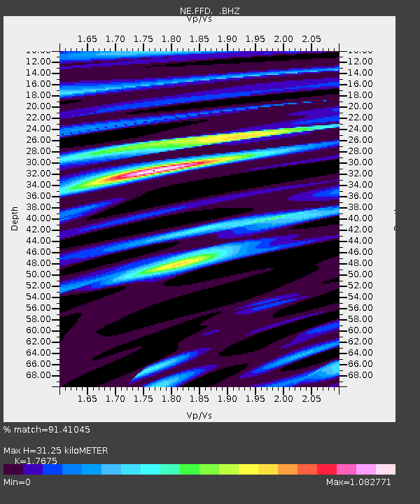
FFD Franklin Falls Dam, NH - Earthquake Result Viewer
| Earthquake location: |
Nicaragua |
| Earthquake latitude/longitude: |
11.6/-85.9 |
| Earthquake time(UTC): |
2011/11/07 (311) 22:35:25 GMT |
| Earthquake Depth: |
177 km |
| Earthquake Magnitude: |
6.0 MB, 6.0 MW, 6.1 MW |
| Earthquake Catalog/Contributor: |
WHDF/NEIC |
|
| Network: |
NE New England Seismic Network |
| Station: |
FFD Franklin Falls Dam, NH |
| Lat/Lon: |
43.47 N/71.65 W |
| Elevation: |
131 m |
|
| Distance: |
34.1 deg |
| Az: |
18.589 deg |
| Baz: |
205.409 deg |
| Ray Param: |
0.077303566 |
| Estimated Moho Depth: |
31.25 km |
| Estimated Crust Vp/Vs: |
1.77 |
| Assumed Crust Vp: |
6.419 km/s |
| Estimated Crust Vs: |
3.632 km/s |
| Estimated Crust Poisson's Ratio: |
0.26 |
|
| Radial Match: |
91.41045 % |
| Radial Bump: |
342 |
| Transverse Match: |
70.297264 % |
| Transverse Bump: |
400 |
| SOD ConfigId: |
424168 |
| Insert Time: |
2012-02-24 05:38:04.584 +0000 |
| GWidth: |
2.5 |
| Max Bumps: |
400 |
| Tol: |
0.001 |
|

Signal To Noise
| Channel | StoN | STA | LTA |
| NE:FFD: :BHZ:20111107T22:41:22.939998Z | 21.788973 | 5.386504E-6 | 2.472124E-7 |
| NE:FFD: :BHN:20111107T22:41:22.939998Z | 12.858958 | 3.2669009E-6 | 2.540564E-7 |
| NE:FFD: :BHE:20111107T22:41:22.939998Z | 6.292301 | 2.0649966E-6 | 3.2817826E-7 |
| Arrivals |
| Ps | 4.0 SECOND |
| PpPs | 12 SECOND |
| PsPs/PpSs | 17 SECOND |


