You are here: Home > Network List > CC - Cascade Chain Volcano Monitoring Stations List
> Station CPCO Central Pumice Cone, Newberry, OR > Earthquake Result Viewer
CPCO Central Pumice Cone, Newberry, OR - Earthquake Result Viewer
| Earthquake location: |
Guerrero, Mexico |
| Earthquake latitude/longitude: |
17.6/-100.8 |
| Earthquake time(UTC): |
2014/04/18 (108) 14:27:26 GMT |
| Earthquake Depth: |
24 km |
| Earthquake Magnitude: |
7.2 MWW, 7.0 MWB, 7.3 MWC, 7.5 MI |
| Earthquake Catalog/Contributor: |
NEIC PDE/NEIC COMCAT |
|
| Network: |
CC Cascade Chain Volcano Monitoring |
| Station: |
CPCO Central Pumice Cone, Newberry, OR |
| Lat/Lon: |
43.72 N/121.23 W |
| Elevation: |
2135 m |
|
| Distance: |
31.3 deg |
| Az: |
330.846 deg |
| Baz: |
140.131 deg |
| Ray Param: |
0.07909358 |
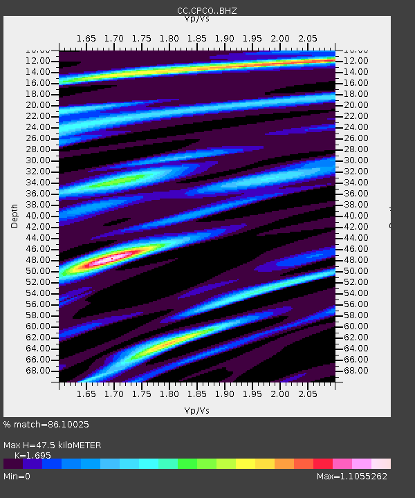
| Estimated Moho Depth: |
47.5 km |
| Estimated Crust Vp/Vs: |
1.70 |
| Assumed Crust Vp: |
6.597 km/s |
| Estimated Crust Vs: |
3.892 km/s |
| Estimated Crust Poisson's Ratio: |
0.23 |
|
| Radial Match: |
86.10025 % |
| Radial Bump: |
400 |
| Transverse Match: |
71.62528 % |
| Transverse Bump: |
400 |
| SOD ConfigId: |
3390531 |
| Insert Time: |
2019-04-11 11:09:44.519 +0000 |
| GWidth: |
2.5 |
| Max Bumps: |
400 |
| Tol: |
0.001 |
|

Signal To Noise
| Channel | StoN | STA | LTA |
| CC:CPCO: :BHZ:20140418T14:33:13.09999Z | 52.31899 | 1.2363206E-5 | 2.3630437E-7 |
| CC:CPCO: :BHN:20140418T14:33:13.09999Z | 15.934144 | 4.432444E-6 | 2.7817268E-7 |
| CC:CPCO: :BHE:20140418T14:33:13.09999Z | 15.673757 | 5.966112E-6 | 3.806434E-7 |
| Arrivals |
| Ps | 5.5 SECOND |
| PpPs | 18 SECOND |
| PsPs/PpSs | 23 SECOND |


