You are here: Home > Network List > G - GEOSCOPE Stations List
> Station HYB Hyderabad, India > Earthquake Result Viewer
HYB Hyderabad, India - Earthquake Result Viewer
| Earthquake location: |
Bering Sea |
| Earthquake latitude/longitude: |
58.4/-175.4 |
| Earthquake time(UTC): |
1991/02/21 (052) 02:35:32 GMT |
| Earthquake Depth: |
10 km |
| Earthquake Magnitude: |
6.3 MB, 6.5 MS, 6.7 UNKNOWN |
| Earthquake Catalog/Contributor: |
WHDF/NEIC |
|
| Network: |
G GEOSCOPE |
| Station: |
HYB Hyderabad, India |
| Lat/Lon: |
17.42 N/78.55 E |
| Elevation: |
510 m |
|
| Distance: |
83.4 deg |
| Az: |
292.512 deg |
| Baz: |
30.611 deg |
| Ray Param: |
0.04619606 |
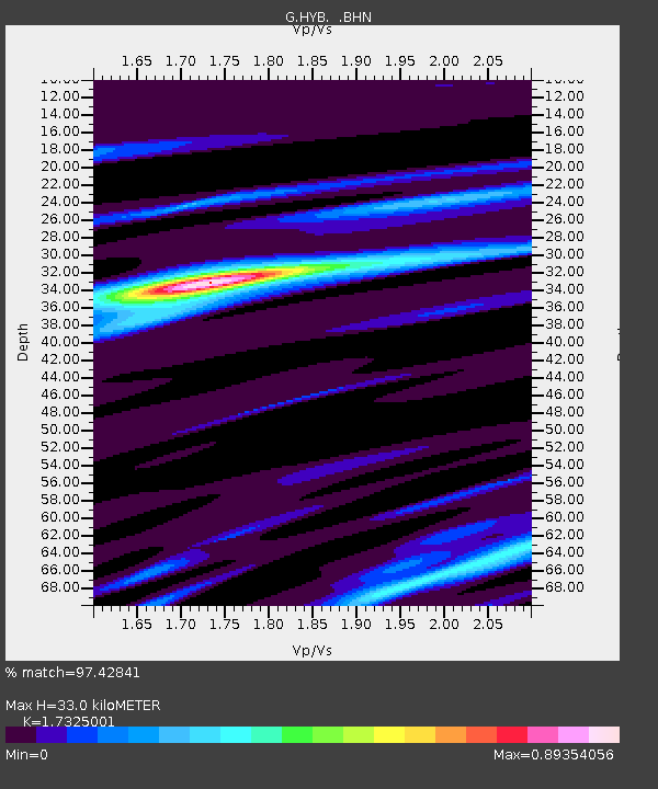
| Estimated Moho Depth: |
33.0 km |
| Estimated Crust Vp/Vs: |
1.73 |
| Assumed Crust Vp: |
6.459 km/s |
| Estimated Crust Vs: |
3.728 km/s |
| Estimated Crust Poisson's Ratio: |
0.25 |
|
| Radial Match: |
97.42841 % |
| Radial Bump: |
255 |
| Transverse Match: |
91.30239 % |
| Transverse Bump: |
400 |
| SOD ConfigId: |
16938 |
| Insert Time: |
2010-02-26 22:47:07.966 +0000 |
| GWidth: |
2.5 |
| Max Bumps: |
400 |
| Tol: |
0.001 |
|

Signal To Noise
| Channel | StoN | STA | LTA |
| G:HYB: :BHN:19910221T02:47:28.449011Z | 3.6312985 | 2.4368546E-7 | 6.710698E-8 |
| G:HYB: :BHE:19910221T02:47:28.449011Z | 2.2928543 | 1.4020705E-7 | 6.114957E-8 |
| G:HYB: :BHZ:19910221T02:47:28.449011Z | 9.074298 | 7.0181835E-7 | 7.734134E-8 |
| Arrivals |
| Ps | 3.8 SECOND |
| PpPs | 14 SECOND |
| PsPs/PpSs | 17 SECOND |


