You are here: Home > Network List > TA - USArray Transportable Network (new EarthScope stations) Stations List
> Station N34A Lincoln, NE, USA > Earthquake Result Viewer
N34A Lincoln, NE, USA - Earthquake Result Viewer
| Earthquake location: |
Nicaragua |
| Earthquake latitude/longitude: |
11.6/-85.9 |
| Earthquake time(UTC): |
2011/11/07 (311) 22:35:25 GMT |
| Earthquake Depth: |
177 km |
| Earthquake Magnitude: |
6.0 MB, 6.0 MW, 6.1 MW |
| Earthquake Catalog/Contributor: |
WHDF/NEIC |
|
| Network: |
TA USArray Transportable Network (new EarthScope stations) |
| Station: |
N34A Lincoln, NE, USA |
| Lat/Lon: |
40.84 N/96.50 W |
| Elevation: |
401 m |
|
| Distance: |
30.6 deg |
| Az: |
344.042 deg |
| Baz: |
159.2 deg |
| Ray Param: |
0.078894906 |
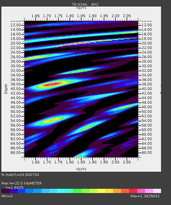
| Estimated Moho Depth: |
20.0 km |
| Estimated Crust Vp/Vs: |
1.84 |
| Assumed Crust Vp: |
6.498 km/s |
| Estimated Crust Vs: |
3.526 km/s |
| Estimated Crust Poisson's Ratio: |
0.29 |
|
| Radial Match: |
84.940704 % |
| Radial Bump: |
400 |
| Transverse Match: |
61.851906 % |
| Transverse Bump: |
400 |
| SOD ConfigId: |
424168 |
| Insert Time: |
2012-02-24 05:40:58.651 +0000 |
| GWidth: |
2.5 |
| Max Bumps: |
400 |
| Tol: |
0.001 |
|
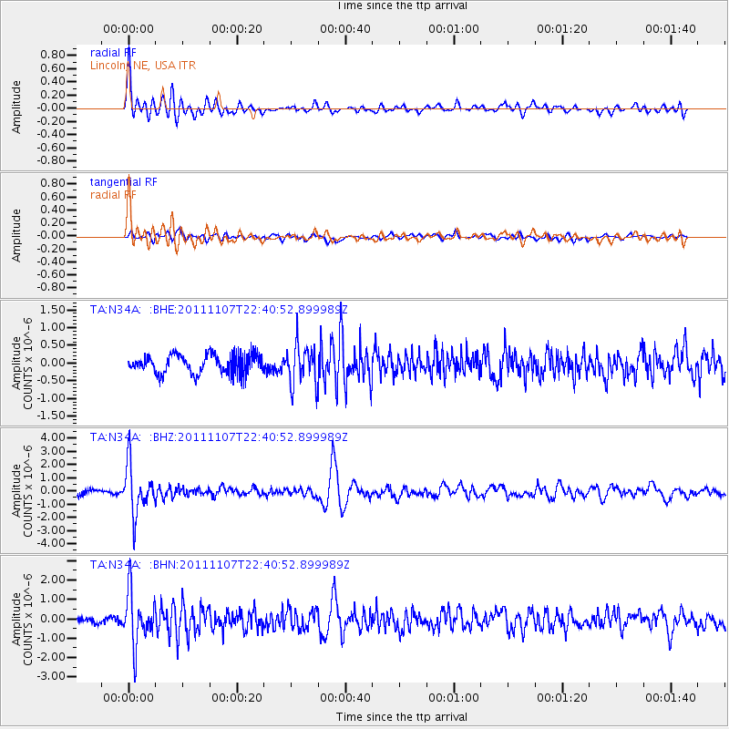
Signal To Noise
| Channel | StoN | STA | LTA |
| TA:N34A: :BHZ:20111107T22:40:52.899989Z | 8.012232 | 1.853735E-6 | 2.3136313E-7 |
| TA:N34A: :BHN:20111107T22:40:52.899989Z | 10.113986 | 1.3582401E-6 | 1.3429324E-7 |
| TA:N34A: :BHE:20111107T22:40:52.899989Z | 2.1003637 | 5.6450614E-7 | 2.687659E-7 |
| Arrivals |
| Ps | 2.8 SECOND |
| PpPs | 8.1 SECOND |
| PsPs/PpSs | 11 SECOND |


