You are here: Home > Network List > TA - USArray Transportable Network (new EarthScope stations) Stations List
> Station O33A Hebron, NE, USA > Earthquake Result Viewer
O33A Hebron, NE, USA - Earthquake Result Viewer
| Earthquake location: |
Nicaragua |
| Earthquake latitude/longitude: |
11.6/-85.9 |
| Earthquake time(UTC): |
2011/11/07 (311) 22:35:25 GMT |
| Earthquake Depth: |
177 km |
| Earthquake Magnitude: |
6.0 MB, 6.0 MW, 6.1 MW |
| Earthquake Catalog/Contributor: |
WHDF/NEIC |
|
| Network: |
TA USArray Transportable Network (new EarthScope stations) |
| Station: |
O33A Hebron, NE, USA |
| Lat/Lon: |
40.08 N/97.58 W |
| Elevation: |
480 m |
|
| Distance: |
30.2 deg |
| Az: |
341.964 deg |
| Baz: |
156.708 deg |
| Ray Param: |
0.07905959 |
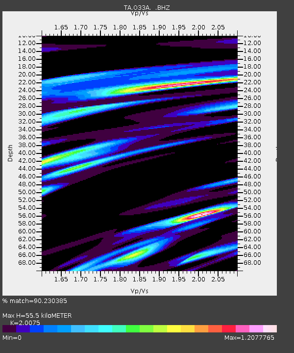
| Estimated Moho Depth: |
55.5 km |
| Estimated Crust Vp/Vs: |
2.01 |
| Assumed Crust Vp: |
6.498 km/s |
| Estimated Crust Vs: |
3.237 km/s |
| Estimated Crust Poisson's Ratio: |
0.33 |
|
| Radial Match: |
90.230385 % |
| Radial Bump: |
298 |
| Transverse Match: |
66.9913 % |
| Transverse Bump: |
400 |
| SOD ConfigId: |
424168 |
| Insert Time: |
2012-02-24 05:41:15.573 +0000 |
| GWidth: |
2.5 |
| Max Bumps: |
400 |
| Tol: |
0.001 |
|

Signal To Noise
| Channel | StoN | STA | LTA |
| TA:O33A: :BHZ:20111107T22:40:49.450007Z | 11.847434 | 2.2255758E-6 | 1.8785298E-7 |
| TA:O33A: :BHN:20111107T22:40:49.450007Z | 7.7395773 | 1.4995896E-6 | 1.9375602E-7 |
| TA:O33A: :BHE:20111107T22:40:49.450007Z | 3.0637264 | 6.841764E-7 | 2.2331511E-7 |
| Arrivals |
| Ps | 9.2 SECOND |
| PpPs | 24 SECOND |
| PsPs/PpSs | 33 SECOND |


