You are here: Home > Network List > G - GEOSCOPE Stations List
> Station HYB Hyderabad, India > Earthquake Result Viewer
HYB Hyderabad, India - Earthquake Result Viewer
| Earthquake location: |
Rat Islands, Aleutian Islands |
| Earthquake latitude/longitude: |
52.0/178.9 |
| Earthquake time(UTC): |
1991/01/23 (023) 01:12:30 GMT |
| Earthquake Depth: |
116 km |
| Earthquake Magnitude: |
5.9 MB |
| Earthquake Catalog/Contributor: |
WHDF/NEIC |
|
| Network: |
G GEOSCOPE |
| Station: |
HYB Hyderabad, India |
| Lat/Lon: |
17.42 N/78.55 E |
| Elevation: |
510 m |
|
| Distance: |
82.6 deg |
| Az: |
288.709 deg |
| Baz: |
37.814 deg |
| Ray Param: |
0.04649979 |
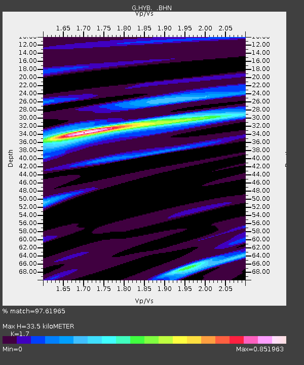
| Estimated Moho Depth: |
33.5 km |
| Estimated Crust Vp/Vs: |
1.70 |
| Assumed Crust Vp: |
6.459 km/s |
| Estimated Crust Vs: |
3.8 km/s |
| Estimated Crust Poisson's Ratio: |
0.24 |
|
| Radial Match: |
97.61965 % |
| Radial Bump: |
310 |
| Transverse Match: |
87.62991 % |
| Transverse Bump: |
400 |
| SOD ConfigId: |
17000 |
| Insert Time: |
2010-02-26 22:47:14.449 +0000 |
| GWidth: |
2.5 |
| Max Bumps: |
400 |
| Tol: |
0.001 |
|

Signal To Noise
| Channel | StoN | STA | LTA |
| G:HYB: :BHN:19910123T01:24:09.999011Z | 11.020683 | 4.1197185E-7 | 3.7381696E-8 |
| G:HYB: :BHE:19910123T01:24:09.999011Z | 7.716163 | 2.9172514E-7 | 3.7807023E-8 |
| G:HYB: :BHZ:19910123T01:24:09.999011Z | 24.487627 | 1.4044198E-6 | 5.735222E-8 |
| Arrivals |
| Ps | 3.7 SECOND |
| PpPs | 14 SECOND |
| PsPs/PpSs | 17 SECOND |


