You are here: Home > Network List > TA - USArray Transportable Network (new EarthScope stations) Stations List
> Station I34A Hadley, MN, USA > Earthquake Result Viewer
I34A Hadley, MN, USA - Earthquake Result Viewer
| Earthquake location: |
Nicaragua |
| Earthquake latitude/longitude: |
11.6/-85.9 |
| Earthquake time(UTC): |
2011/11/07 (311) 22:35:25 GMT |
| Earthquake Depth: |
177 km |
| Earthquake Magnitude: |
6.0 MB, 6.0 MW, 6.1 MW |
| Earthquake Catalog/Contributor: |
WHDF/NEIC |
|
| Network: |
TA USArray Transportable Network (new EarthScope stations) |
| Station: |
I34A Hadley, MN, USA |
| Lat/Lon: |
44.04 N/95.86 W |
| Elevation: |
509 m |
|
| Distance: |
33.5 deg |
| Az: |
346.885 deg |
| Baz: |
162.041 deg |
| Ray Param: |
0.07760911 |
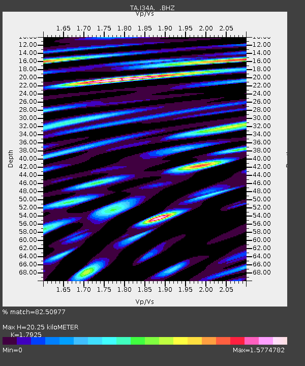
| Estimated Moho Depth: |
20.25 km |
| Estimated Crust Vp/Vs: |
1.79 |
| Assumed Crust Vp: |
6.571 km/s |
| Estimated Crust Vs: |
3.666 km/s |
| Estimated Crust Poisson's Ratio: |
0.27 |
|
| Radial Match: |
82.50977 % |
| Radial Bump: |
400 |
| Transverse Match: |
72.236725 % |
| Transverse Bump: |
400 |
| SOD ConfigId: |
424168 |
| Insert Time: |
2012-02-24 05:42:23.677 +0000 |
| GWidth: |
2.5 |
| Max Bumps: |
400 |
| Tol: |
0.001 |
|

Signal To Noise
| Channel | StoN | STA | LTA |
| TA:I34A: :BHZ:20111107T22:41:17.774989Z | 17.625916 | 3.0948827E-6 | 1.7558706E-7 |
| TA:I34A: :BHN:20111107T22:41:17.774989Z | 15.071854 | 2.5376482E-6 | 1.6837002E-7 |
| TA:I34A: :BHE:20111107T22:41:17.774989Z | 7.1634994 | 1.0558822E-6 | 1.4739754E-7 |
| Arrivals |
| Ps | 2.6 SECOND |
| PpPs | 7.9 SECOND |
| PsPs/PpSs | 11 SECOND |


