You are here: Home > Network List > TA - USArray Transportable Network (new EarthScope stations) Stations List
> Station I35A Creekview Farms, Bingham Lake, MN, USA > Earthquake Result Viewer
I35A Creekview Farms, Bingham Lake, MN, USA - Earthquake Result Viewer
| Earthquake location: |
Nicaragua |
| Earthquake latitude/longitude: |
11.6/-85.9 |
| Earthquake time(UTC): |
2011/11/07 (311) 22:35:25 GMT |
| Earthquake Depth: |
177 km |
| Earthquake Magnitude: |
6.0 MB, 6.0 MW, 6.1 MW |
| Earthquake Catalog/Contributor: |
WHDF/NEIC |
|
| Network: |
TA USArray Transportable Network (new EarthScope stations) |
| Station: |
I35A Creekview Farms, Bingham Lake, MN, USA |
| Lat/Lon: |
43.86 N/94.98 W |
| Elevation: |
428 m |
|
| Distance: |
33.1 deg |
| Az: |
347.888 deg |
| Baz: |
163.486 deg |
| Ray Param: |
0.077793635 |
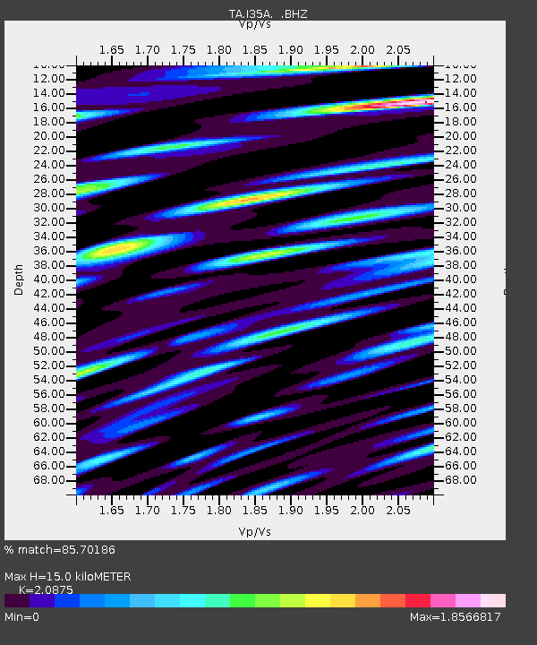
| Estimated Moho Depth: |
15.0 km |
| Estimated Crust Vp/Vs: |
2.09 |
| Assumed Crust Vp: |
6.53 km/s |
| Estimated Crust Vs: |
3.128 km/s |
| Estimated Crust Poisson's Ratio: |
0.35 |
|
| Radial Match: |
85.70186 % |
| Radial Bump: |
400 |
| Transverse Match: |
72.34428 % |
| Transverse Bump: |
400 |
| SOD ConfigId: |
424168 |
| Insert Time: |
2012-02-24 05:42:46.703 +0000 |
| GWidth: |
2.5 |
| Max Bumps: |
400 |
| Tol: |
0.001 |
|

Signal To Noise
| Channel | StoN | STA | LTA |
| TA:I35A: :BHZ:20111107T22:41:14.649989Z | 24.470491 | 4.4186586E-6 | 1.8057091E-7 |
| TA:I35A: :BHN:20111107T22:41:14.649989Z | 29.473705 | 5.3018402E-6 | 1.7988373E-7 |
| TA:I35A: :BHE:20111107T22:41:14.649989Z | 8.258667 | 1.5342986E-6 | 1.8578042E-7 |
| Arrivals |
| Ps | 2.7 SECOND |
| PpPs | 6.6 SECOND |
| PsPs/PpSs | 9.3 SECOND |


