You are here: Home > Network List > G - GEOSCOPE Stations List
> Station HYB Hyderabad, India > Earthquake Result Viewer
HYB Hyderabad, India - Earthquake Result Viewer
| Earthquake location: |
Minahassa Peninsula, Sulawesi |
| Earthquake latitude/longitude: |
1.1/124.0 |
| Earthquake time(UTC): |
1992/06/06 (158) 21:40:41 GMT |
| Earthquake Depth: |
25 km |
| Earthquake Magnitude: |
5.8 MB, 5.6 MS |
| Earthquake Catalog/Contributor: |
WHDF/NEIC |
|
| Network: |
G GEOSCOPE |
| Station: |
HYB Hyderabad, India |
| Lat/Lon: |
17.42 N/78.55 E |
| Elevation: |
510 m |
|
| Distance: |
47.5 deg |
| Az: |
292.742 deg |
| Baz: |
105.022 deg |
| Ray Param: |
0.06990544 |
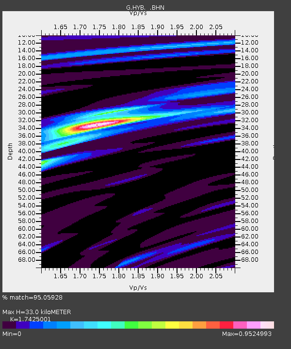
| Estimated Moho Depth: |
33.0 km |
| Estimated Crust Vp/Vs: |
1.74 |
| Assumed Crust Vp: |
6.459 km/s |
| Estimated Crust Vs: |
3.707 km/s |
| Estimated Crust Poisson's Ratio: |
0.25 |
|
| Radial Match: |
95.05928 % |
| Radial Bump: |
268 |
| Transverse Match: |
81.918724 % |
| Transverse Bump: |
400 |
| SOD ConfigId: |
4480 |
| Insert Time: |
2010-02-26 22:47:18.012 +0000 |
| GWidth: |
2.5 |
| Max Bumps: |
400 |
| Tol: |
0.001 |
|

Signal To Noise
| Channel | StoN | STA | LTA |
| G:HYB: :BHN:19920606T21:48:43.791986Z | 3.7402594 | 2.7862404E-7 | 7.449324E-8 |
| G:HYB: :BHE:19920606T21:48:43.791986Z | 0.9088652 | 5.326708E-8 | 5.8608343E-8 |
| G:HYB: :BHZ:19920606T21:48:43.791986Z | 2.3791935 | 1.4296538E-7 | 6.0089846E-8 |
| Arrivals |
| Ps | 4.0 SECOND |
| PpPs | 13 SECOND |
| PsPs/PpSs | 17 SECOND |


