You are here: Home > Network List > TA - USArray Transportable Network (new EarthScope stations) Stations List
> Station H33A Prehn Over North, Clear Lake, SD, USA > Earthquake Result Viewer
H33A Prehn Over North, Clear Lake, SD, USA - Earthquake Result Viewer
| Earthquake location: |
Nicaragua |
| Earthquake latitude/longitude: |
11.6/-85.9 |
| Earthquake time(UTC): |
2011/11/07 (311) 22:35:25 GMT |
| Earthquake Depth: |
177 km |
| Earthquake Magnitude: |
6.0 MB, 6.0 MW, 6.1 MW |
| Earthquake Catalog/Contributor: |
WHDF/NEIC |
|
| Network: |
TA USArray Transportable Network (new EarthScope stations) |
| Station: |
H33A Prehn Over North, Clear Lake, SD, USA |
| Lat/Lon: |
44.68 N/96.74 W |
| Elevation: |
584 m |
|
| Distance: |
34.3 deg |
| Az: |
346.174 deg |
| Baz: |
160.836 deg |
| Ray Param: |
0.07719333 |
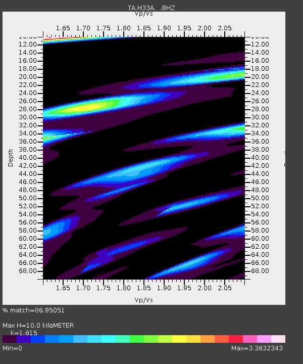
| Estimated Moho Depth: |
10.0 km |
| Estimated Crust Vp/Vs: |
1.62 |
| Assumed Crust Vp: |
6.552 km/s |
| Estimated Crust Vs: |
4.057 km/s |
| Estimated Crust Poisson's Ratio: |
0.19 |
|
| Radial Match: |
86.95051 % |
| Radial Bump: |
364 |
| Transverse Match: |
71.57676 % |
| Transverse Bump: |
392 |
| SOD ConfigId: |
424168 |
| Insert Time: |
2012-02-24 05:43:02.448 +0000 |
| GWidth: |
2.5 |
| Max Bumps: |
400 |
| Tol: |
0.001 |
|

Signal To Noise
| Channel | StoN | STA | LTA |
| TA:H33A: :BHZ:20111107T22:41:24.749995Z | 9.981637 | 2.245234E-6 | 2.2493647E-7 |
| TA:H33A: :BHN:20111107T22:41:24.749995Z | 7.9957247 | 3.8493467E-6 | 4.814257E-7 |
| TA:H33A: :BHE:20111107T22:41:24.749995Z | 2.3617272 | 8.8040156E-7 | 3.727787E-7 |
| Arrivals |
| Ps | 1.0 SECOND |
| PpPs | 3.7 SECOND |
| PsPs/PpSs | 4.7 SECOND |


