You are here: Home > Network List > TA - USArray Transportable Network (new EarthScope stations) Stations List
> Station J31A Geddes, SD, USA > Earthquake Result Viewer
J31A Geddes, SD, USA - Earthquake Result Viewer
| Earthquake location: |
Nicaragua |
| Earthquake latitude/longitude: |
11.6/-85.9 |
| Earthquake time(UTC): |
2011/11/07 (311) 22:35:25 GMT |
| Earthquake Depth: |
177 km |
| Earthquake Magnitude: |
6.0 MB, 6.0 MW, 6.1 MW |
| Earthquake Catalog/Contributor: |
WHDF/NEIC |
|
| Network: |
TA USArray Transportable Network (new EarthScope stations) |
| Station: |
J31A Geddes, SD, USA |
| Lat/Lon: |
43.29 N/98.74 W |
| Elevation: |
491 m |
|
| Distance: |
33.5 deg |
| Az: |
342.865 deg |
| Baz: |
156.708 deg |
| Ray Param: |
0.077590354 |
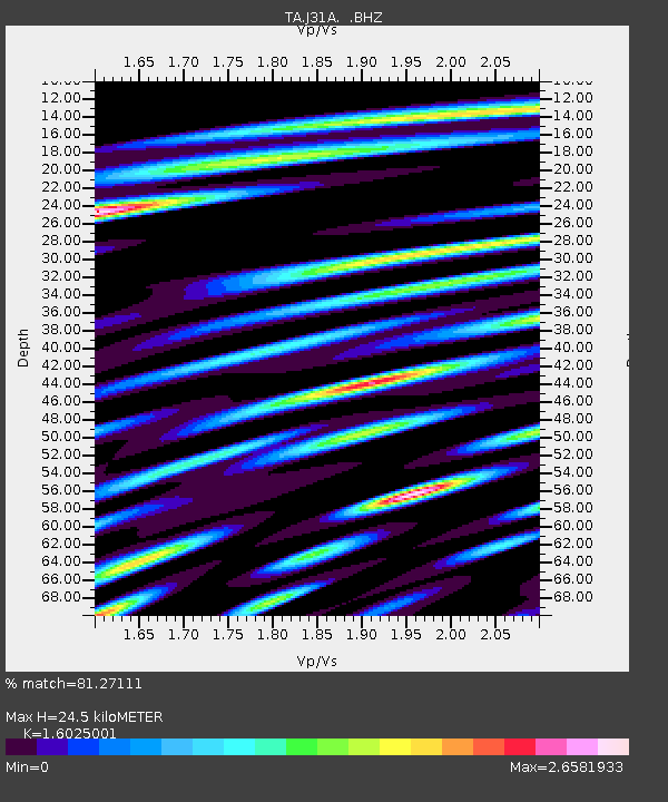
| Estimated Moho Depth: |
24.5 km |
| Estimated Crust Vp/Vs: |
1.60 |
| Assumed Crust Vp: |
6.53 km/s |
| Estimated Crust Vs: |
4.075 km/s |
| Estimated Crust Poisson's Ratio: |
0.18 |
|
| Radial Match: |
81.27111 % |
| Radial Bump: |
400 |
| Transverse Match: |
61.50656 % |
| Transverse Bump: |
400 |
| SOD ConfigId: |
424168 |
| Insert Time: |
2012-02-24 05:43:26.800 +0000 |
| GWidth: |
2.5 |
| Max Bumps: |
400 |
| Tol: |
0.001 |
|
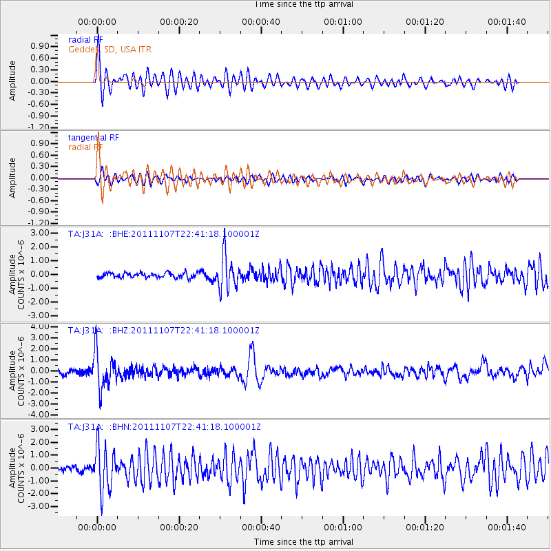
Signal To Noise
| Channel | StoN | STA | LTA |
| TA:J31A: :BHZ:20111107T22:41:18.100001Z | 10.080166 | 1.6962085E-6 | 1.6827188E-7 |
| TA:J31A: :BHN:20111107T22:41:18.100001Z | 8.926046 | 1.7356052E-6 | 1.9444278E-7 |
| TA:J31A: :BHE:20111107T22:41:18.100001Z | 6.987543 | 1.2360038E-6 | 1.7688674E-7 |
| Arrivals |
| Ps | 2.5 SECOND |
| PpPs | 8.9 SECOND |
| PsPs/PpSs | 11 SECOND |


