You are here: Home > Network List > TA - USArray Transportable Network (new EarthScope stations) Stations List
> Station O03D Paynes Creek, CA, USA > Earthquake Result Viewer
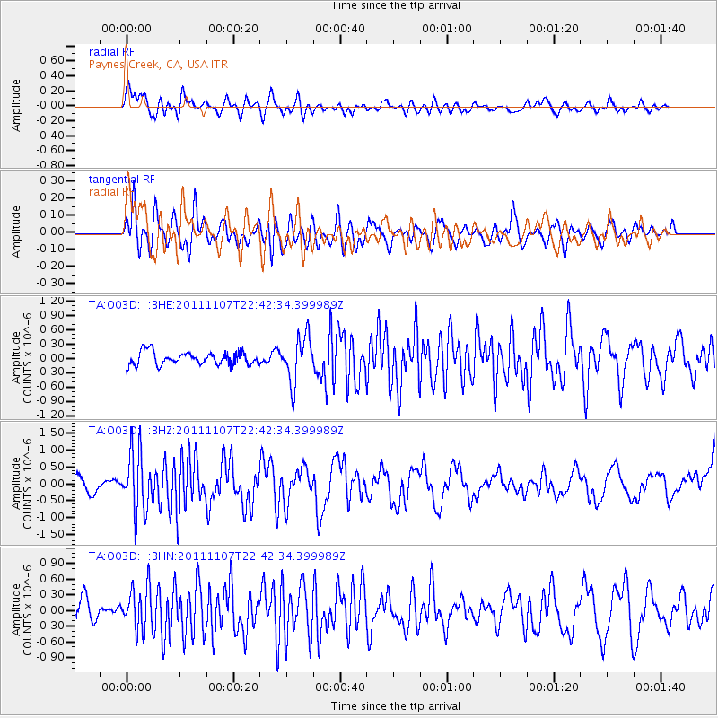
O03D Paynes Creek, CA, USA - Earthquake Result Viewer
*The percent match for this event was below the threshold and hence no stack was calculated.
| Earthquake location: |
Nicaragua |
| Earthquake latitude/longitude: |
11.6/-85.9 |
| Earthquake time(UTC): |
2011/11/07 (311) 22:35:25 GMT |
| Earthquake Depth: |
177 km |
| Earthquake Magnitude: |
6.0 MB, 6.0 MW, 6.1 MW |
| Earthquake Catalog/Contributor: |
WHDF/NEIC |
|
| Network: |
TA USArray Transportable Network (new EarthScope stations) |
| Station: |
O03D Paynes Creek, CA, USA |
| Lat/Lon: |
40.29 N/121.80 W |
| Elevation: |
968 m |
|
| Distance: |
42.7 deg |
| Az: |
318.532 deg |
| Baz: |
121.957 deg |
| Ray Param: |
$rayparam |
*The percent match for this event was below the threshold and hence was not used in the summary stack. |
|
| Radial Match: |
60.957417 % |
| Radial Bump: |
400 |
| Transverse Match: |
54.67101 % |
| Transverse Bump: |
400 |
| SOD ConfigId: |
424168 |
| Insert Time: |
2012-02-24 05:43:40.200 +0000 |
| GWidth: |
2.5 |
| Max Bumps: |
400 |
| Tol: |
0.001 |
|
Signal To Noise
| Channel | StoN | STA | LTA |
| TA:O03D: :BHZ:20111107T22:42:34.399989Z | 3.5698438 | 8.884104E-7 | 2.4886535E-7 |
| TA:O03D: :BHN:20111107T22:42:34.399989Z | 2.0419743 | 4.008931E-7 | 1.9632624E-7 |
| TA:O03D: :BHE:20111107T22:42:34.399989Z | 3.6234934 | 4.8557274E-7 | 1.340068E-7 |
| Arrivals |
| Ps | |
| PpPs | |
| PsPs/PpSs | |


