You are here: Home > Network List > TA - USArray Transportable Network (new EarthScope stations) Stations List
> Station A04D Lummi Island, WA, USA > Earthquake Result Viewer
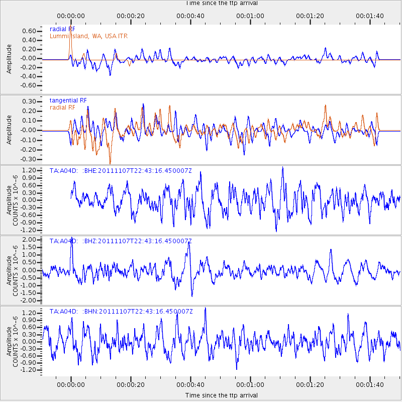
A04D Lummi Island, WA, USA - Earthquake Result Viewer
*The percent match for this event was below the threshold and hence no stack was calculated.
| Earthquake location: |
Nicaragua |
| Earthquake latitude/longitude: |
11.6/-85.9 |
| Earthquake time(UTC): |
2011/11/07 (311) 22:35:25 GMT |
| Earthquake Depth: |
177 km |
| Earthquake Magnitude: |
6.0 MB, 6.0 MW, 6.1 MW |
| Earthquake Catalog/Contributor: |
WHDF/NEIC |
|
| Network: |
TA USArray Transportable Network (new EarthScope stations) |
| Station: |
A04D Lummi Island, WA, USA |
| Lat/Lon: |
48.72 N/122.71 W |
| Elevation: |
13 m |
|
| Distance: |
48.0 deg |
| Az: |
327.725 deg |
| Baz: |
127.796 deg |
| Ray Param: |
$rayparam |
*The percent match for this event was below the threshold and hence was not used in the summary stack. |
|
| Radial Match: |
63.788074 % |
| Radial Bump: |
400 |
| Transverse Match: |
50.857124 % |
| Transverse Bump: |
400 |
| SOD ConfigId: |
424168 |
| Insert Time: |
2012-02-24 05:44:24.204 +0000 |
| GWidth: |
2.5 |
| Max Bumps: |
400 |
| Tol: |
0.001 |
|
Signal To Noise
| Channel | StoN | STA | LTA |
| TA:A04D: :BHZ:20111107T22:43:16.450007Z | 2.3012955 | 7.8220296E-7 | 3.398968E-7 |
| TA:A04D: :BHN:20111107T22:43:16.450007Z | 1.4330913 | 5.3303256E-7 | 3.7194602E-7 |
| TA:A04D: :BHE:20111107T22:43:16.450007Z | 1.4325488 | 4.821715E-7 | 3.3658299E-7 |
| Arrivals |
| Ps | |
| PpPs | |
| PsPs/PpSs | |


