You are here: Home > Network List > TA - USArray Transportable Network (new EarthScope stations) Stations List
> Station D49A Beulah Township, ON, CAN > Earthquake Result Viewer
D49A Beulah Township, ON, CAN - Earthquake Result Viewer
| Earthquake location: |
Guerrero, Mexico |
| Earthquake latitude/longitude: |
17.6/-100.8 |
| Earthquake time(UTC): |
2014/04/18 (108) 14:27:26 GMT |
| Earthquake Depth: |
24 km |
| Earthquake Magnitude: |
7.2 MWW, 7.0 MWB, 7.3 MWC, 7.5 MI |
| Earthquake Catalog/Contributor: |
NEIC PDE/NEIC COMCAT |
|
| Network: |
TA USArray Transportable Network (new EarthScope stations) |
| Station: |
D49A Beulah Township, ON, CAN |
| Lat/Lon: |
47.27 N/81.36 W |
| Elevation: |
416 m |
|
| Distance: |
33.7 deg |
| Az: |
24.14 deg |
| Baz: |
214.957 deg |
| Ray Param: |
0.07806031 |
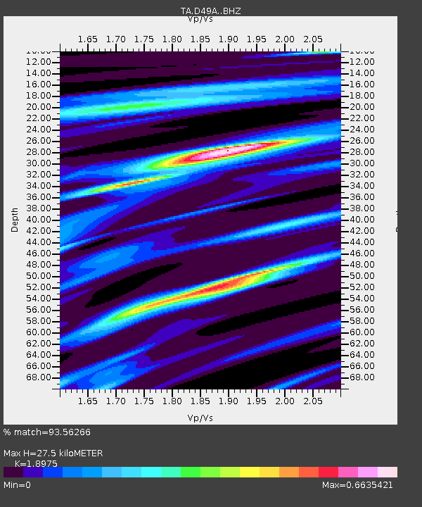
| Estimated Moho Depth: |
27.5 km |
| Estimated Crust Vp/Vs: |
1.90 |
| Assumed Crust Vp: |
6.467 km/s |
| Estimated Crust Vs: |
3.408 km/s |
| Estimated Crust Poisson's Ratio: |
0.31 |
|
| Radial Match: |
93.56266 % |
| Radial Bump: |
316 |
| Transverse Match: |
75.211845 % |
| Transverse Bump: |
400 |
| SOD ConfigId: |
3390531 |
| Insert Time: |
2019-04-11 11:11:53.075 +0000 |
| GWidth: |
2.5 |
| Max Bumps: |
400 |
| Tol: |
0.001 |
|

Signal To Noise
| Channel | StoN | STA | LTA |
| TA:D49A: :BHZ:20140418T14:33:35.550002Z | 88.284454 | 1.1571069E-5 | 1.3106576E-7 |
| TA:D49A: :BHN:20140418T14:33:35.550002Z | 44.149094 | 6.532077E-6 | 1.4795495E-7 |
| TA:D49A: :BHE:20140418T14:33:35.550002Z | 33.111214 | 4.6591094E-6 | 1.4071092E-7 |
| Arrivals |
| Ps | 4.1 SECOND |
| PpPs | 11 SECOND |
| PsPs/PpSs | 16 SECOND |


