You are here: Home > Network List > TA - USArray Transportable Network (new EarthScope stations) Stations List
> Station H46A Fife Lake, MI, USA > Earthquake Result Viewer
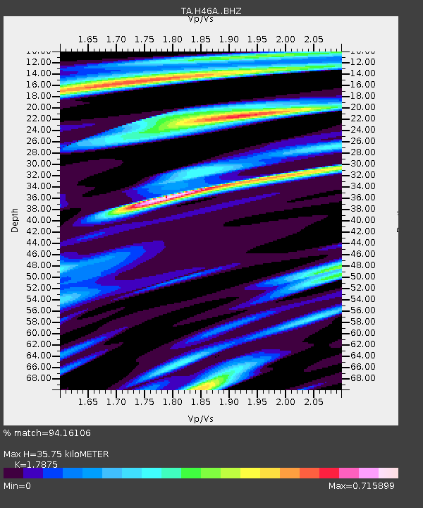
H46A Fife Lake, MI, USA - Earthquake Result Viewer
| Earthquake location: |
Guerrero, Mexico |
| Earthquake latitude/longitude: |
17.6/-100.8 |
| Earthquake time(UTC): |
2014/04/18 (108) 14:27:26 GMT |
| Earthquake Depth: |
24 km |
| Earthquake Magnitude: |
7.2 MWW, 7.0 MWB, 7.3 MWC, 7.5 MI |
| Earthquake Catalog/Contributor: |
NEIC PDE/NEIC COMCAT |
|
| Network: |
TA USArray Transportable Network (new EarthScope stations) |
| Station: |
H46A Fife Lake, MI, USA |
| Lat/Lon: |
44.54 N/85.20 W |
| Elevation: |
329 m |
|
| Distance: |
29.9 deg |
| Az: |
22.685 deg |
| Baz: |
210.964 deg |
| Ray Param: |
0.07944577 |
| Estimated Moho Depth: |
35.75 km |
| Estimated Crust Vp/Vs: |
1.79 |
| Assumed Crust Vp: |
6.483 km/s |
| Estimated Crust Vs: |
3.627 km/s |
| Estimated Crust Poisson's Ratio: |
0.27 |
|
| Radial Match: |
94.16106 % |
| Radial Bump: |
400 |
| Transverse Match: |
70.80809 % |
| Transverse Bump: |
400 |
| SOD ConfigId: |
3390531 |
| Insert Time: |
2019-04-11 11:12:01.303 +0000 |
| GWidth: |
2.5 |
| Max Bumps: |
400 |
| Tol: |
0.001 |
|

Signal To Noise
| Channel | StoN | STA | LTA |
| TA:H46A: :BHZ:20140418T14:33:02.699996Z | 12.702486 | 1.1886537E-5 | 9.3576466E-7 |
| TA:H46A: :BHN:20140418T14:33:02.699996Z | 18.844831 | 7.815882E-6 | 4.1474934E-7 |
| TA:H46A: :BHE:20140418T14:33:02.699996Z | 13.990133 | 4.512887E-6 | 3.2257637E-7 |
| Arrivals |
| Ps | 4.7 SECOND |
| PpPs | 14 SECOND |
| PsPs/PpSs | 19 SECOND |


