You are here: Home > Network List > TA - USArray Transportable Network (new EarthScope stations) Stations List
> Station SUSD Miller, SD, USA > Earthquake Result Viewer
SUSD Miller, SD, USA - Earthquake Result Viewer
| Earthquake location: |
Nicaragua |
| Earthquake latitude/longitude: |
11.6/-85.9 |
| Earthquake time(UTC): |
2011/11/07 (311) 22:35:25 GMT |
| Earthquake Depth: |
177 km |
| Earthquake Magnitude: |
6.0 MB, 6.0 MW, 6.1 MW |
| Earthquake Catalog/Contributor: |
WHDF/NEIC |
|
| Network: |
TA USArray Transportable Network (new EarthScope stations) |
| Station: |
SUSD Miller, SD, USA |
| Lat/Lon: |
44.44 N/98.96 W |
| Elevation: |
520 m |
|
| Distance: |
34.7 deg |
| Az: |
343.416 deg |
| Baz: |
157.015 deg |
| Ray Param: |
0.077008665 |
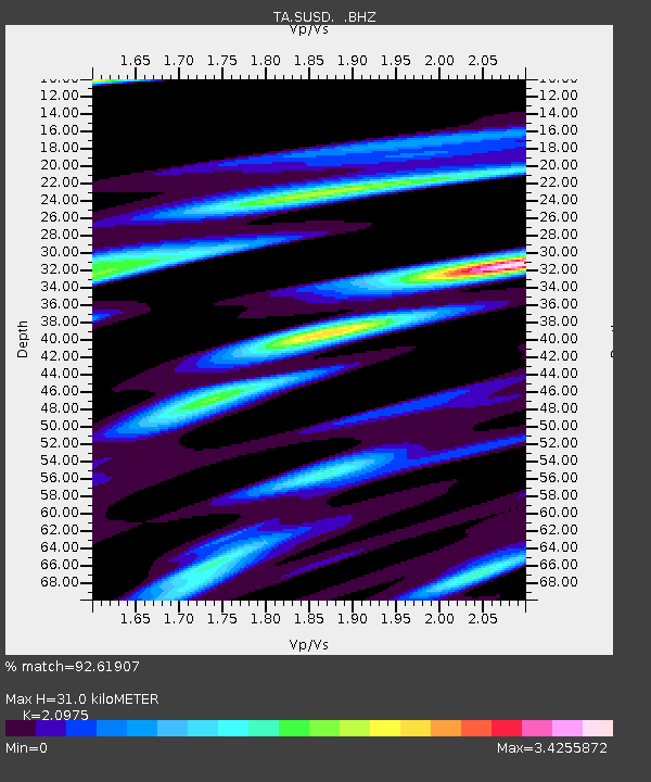
| Estimated Moho Depth: |
31.0 km |
| Estimated Crust Vp/Vs: |
2.10 |
| Assumed Crust Vp: |
6.53 km/s |
| Estimated Crust Vs: |
3.113 km/s |
| Estimated Crust Poisson's Ratio: |
0.35 |
|
| Radial Match: |
92.61907 % |
| Radial Bump: |
386 |
| Transverse Match: |
77.914375 % |
| Transverse Bump: |
388 |
| SOD ConfigId: |
424168 |
| Insert Time: |
2012-02-24 05:45:17.257 +0000 |
| GWidth: |
2.5 |
| Max Bumps: |
400 |
| Tol: |
0.001 |
|

Signal To Noise
| Channel | StoN | STA | LTA |
| TA:SUSD: :BHZ:20111107T22:41:27.725001Z | 11.679315 | 2.2387383E-6 | 1.9168404E-7 |
| TA:SUSD: :BHN:20111107T22:41:27.725001Z | 15.80784 | 3.5052205E-6 | 2.2173937E-7 |
| TA:SUSD: :BHE:20111107T22:41:27.725001Z | 5.22568 | 1.5264143E-6 | 2.920987E-7 |
| Arrivals |
| Ps | 5.6 SECOND |
| PpPs | 14 SECOND |
| PsPs/PpSs | 19 SECOND |


