You are here: Home > Network List > TA - USArray Transportable Network (new EarthScope stations) Stations List
> Station D35A Remer, MN, USA > Earthquake Result Viewer
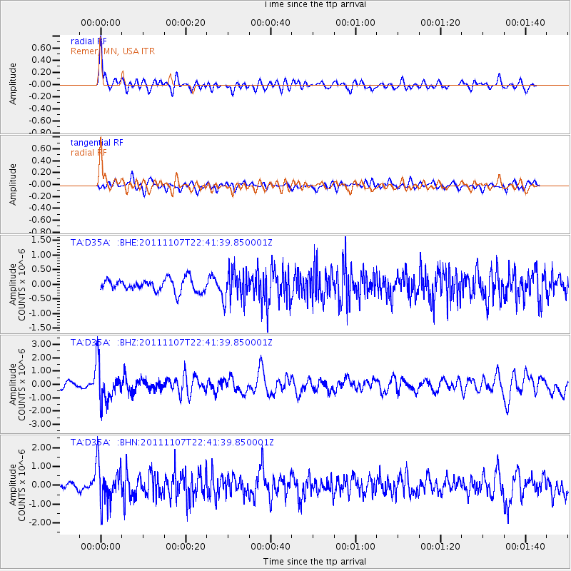
D35A Remer, MN, USA - Earthquake Result Viewer
*The percent match for this event was below the threshold and hence no stack was calculated.
| Earthquake location: |
Nicaragua |
| Earthquake latitude/longitude: |
11.6/-85.9 |
| Earthquake time(UTC): |
2011/11/07 (311) 22:35:25 GMT |
| Earthquake Depth: |
177 km |
| Earthquake Magnitude: |
6.0 MB, 6.0 MW, 6.1 MW |
| Earthquake Catalog/Contributor: |
WHDF/NEIC |
|
| Network: |
TA USArray Transportable Network (new EarthScope stations) |
| Station: |
D35A Remer, MN, USA |
| Lat/Lon: |
47.08 N/94.05 W |
| Elevation: |
427 m |
|
| Distance: |
36.1 deg |
| Az: |
350.481 deg |
| Baz: |
166.282 deg |
| Ray Param: |
$rayparam |
*The percent match for this event was below the threshold and hence was not used in the summary stack. |
|
| Radial Match: |
73.17656 % |
| Radial Bump: |
400 |
| Transverse Match: |
61.143753 % |
| Transverse Bump: |
400 |
| SOD ConfigId: |
424168 |
| Insert Time: |
2012-02-24 05:45:45.075 +0000 |
| GWidth: |
2.5 |
| Max Bumps: |
400 |
| Tol: |
0.001 |
|
Signal To Noise
| Channel | StoN | STA | LTA |
| TA:D35A: :BHZ:20111107T22:41:39.850001Z | 8.764943 | 1.396376E-6 | 1.5931376E-7 |
| TA:D35A: :BHN:20111107T22:41:39.850001Z | 6.3127885 | 1.047696E-6 | 1.6596405E-7 |
| TA:D35A: :BHE:20111107T22:41:39.850001Z | 2.3027143 | 4.964256E-7 | 2.1558282E-7 |
| Arrivals |
| Ps | |
| PpPs | |
| PsPs/PpSs | |


