You are here: Home > Network List > TA - USArray Transportable Network (new EarthScope stations) Stations List
> Station G32A Webster, SD, USA > Earthquake Result Viewer
G32A Webster, SD, USA - Earthquake Result Viewer
| Earthquake location: |
Nicaragua |
| Earthquake latitude/longitude: |
11.6/-85.9 |
| Earthquake time(UTC): |
2011/11/07 (311) 22:35:25 GMT |
| Earthquake Depth: |
177 km |
| Earthquake Magnitude: |
6.0 MB, 6.0 MW, 6.1 MW |
| Earthquake Catalog/Contributor: |
WHDF/NEIC |
|
| Network: |
TA USArray Transportable Network (new EarthScope stations) |
| Station: |
G32A Webster, SD, USA |
| Lat/Lon: |
45.26 N/97.50 W |
| Elevation: |
566 m |
|
| Distance: |
35.0 deg |
| Az: |
345.625 deg |
| Baz: |
159.852 deg |
| Ray Param: |
0.07680715 |
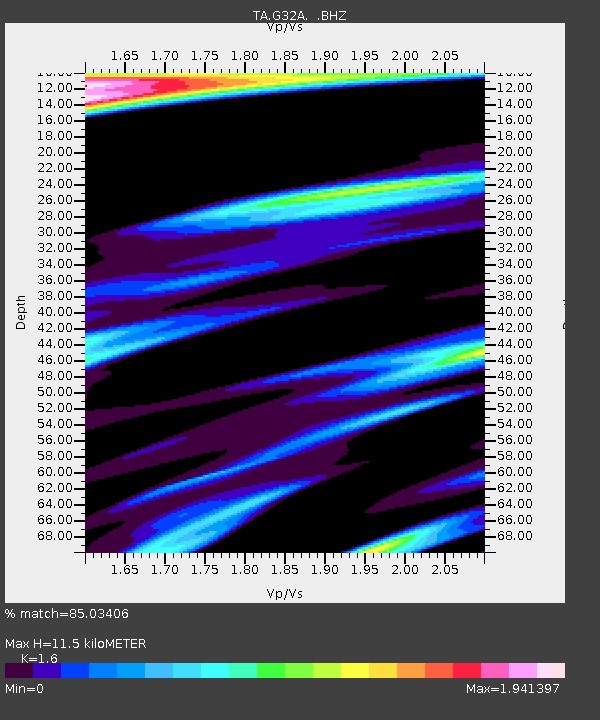
| Estimated Moho Depth: |
11.5 km |
| Estimated Crust Vp/Vs: |
1.60 |
| Assumed Crust Vp: |
6.552 km/s |
| Estimated Crust Vs: |
4.095 km/s |
| Estimated Crust Poisson's Ratio: |
0.18 |
|
| Radial Match: |
85.03406 % |
| Radial Bump: |
322 |
| Transverse Match: |
54.90564 % |
| Transverse Bump: |
368 |
| SOD ConfigId: |
424168 |
| Insert Time: |
2012-02-24 05:46:11.378 +0000 |
| GWidth: |
2.5 |
| Max Bumps: |
400 |
| Tol: |
0.001 |
|

Signal To Noise
| Channel | StoN | STA | LTA |
| TA:G32A: :BHZ:20111107T22:41:30.925013Z | 17.490227 | 3.5690005E-6 | 2.0405685E-7 |
| TA:G32A: :BHN:20111107T22:41:30.925013Z | 9.706718 | 4.502258E-6 | 4.6382905E-7 |
| TA:G32A: :BHE:20111107T22:41:30.925013Z | 4.877631 | 1.3320778E-6 | 2.7309932E-7 |
| Arrivals |
| Ps | 1.1 SECOND |
| PpPs | 4.2 SECOND |
| PsPs/PpSs | 5.3 SECOND |


