You are here: Home > Network List > TA - USArray Transportable Network (new EarthScope stations) Stations List
> Station F31A Hecla, SD, USA > Earthquake Result Viewer
F31A Hecla, SD, USA - Earthquake Result Viewer
| Earthquake location: |
Nicaragua |
| Earthquake latitude/longitude: |
11.6/-85.9 |
| Earthquake time(UTC): |
2011/11/07 (311) 22:35:25 GMT |
| Earthquake Depth: |
177 km |
| Earthquake Magnitude: |
6.0 MB, 6.0 MW, 6.1 MW |
| Earthquake Catalog/Contributor: |
WHDF/NEIC |
|
| Network: |
TA USArray Transportable Network (new EarthScope stations) |
| Station: |
F31A Hecla, SD, USA |
| Lat/Lon: |
45.86 N/98.25 W |
| Elevation: |
412 m |
|
| Distance: |
35.8 deg |
| Az: |
345.137 deg |
| Baz: |
158.918 deg |
| Ray Param: |
0.076402985 |
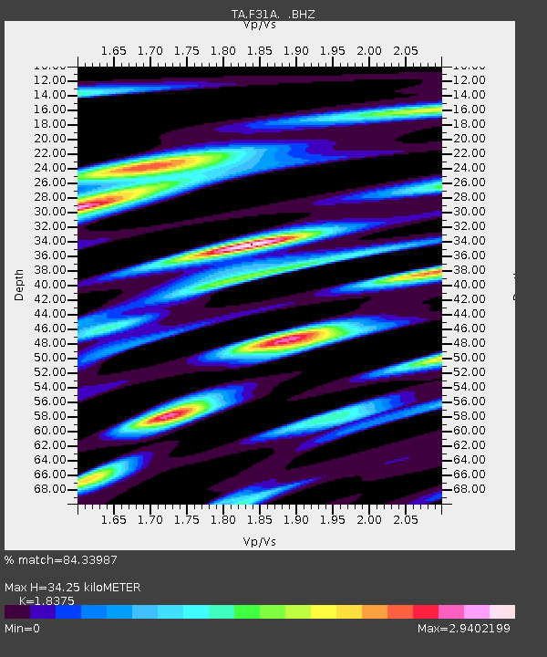
| Estimated Moho Depth: |
34.25 km |
| Estimated Crust Vp/Vs: |
1.84 |
| Assumed Crust Vp: |
6.53 km/s |
| Estimated Crust Vs: |
3.554 km/s |
| Estimated Crust Poisson's Ratio: |
0.29 |
|
| Radial Match: |
84.33987 % |
| Radial Bump: |
343 |
| Transverse Match: |
73.559814 % |
| Transverse Bump: |
363 |
| SOD ConfigId: |
424168 |
| Insert Time: |
2012-02-24 05:46:24.378 +0000 |
| GWidth: |
2.5 |
| Max Bumps: |
400 |
| Tol: |
0.001 |
|
Signal To Noise
| Channel | StoN | STA | LTA |
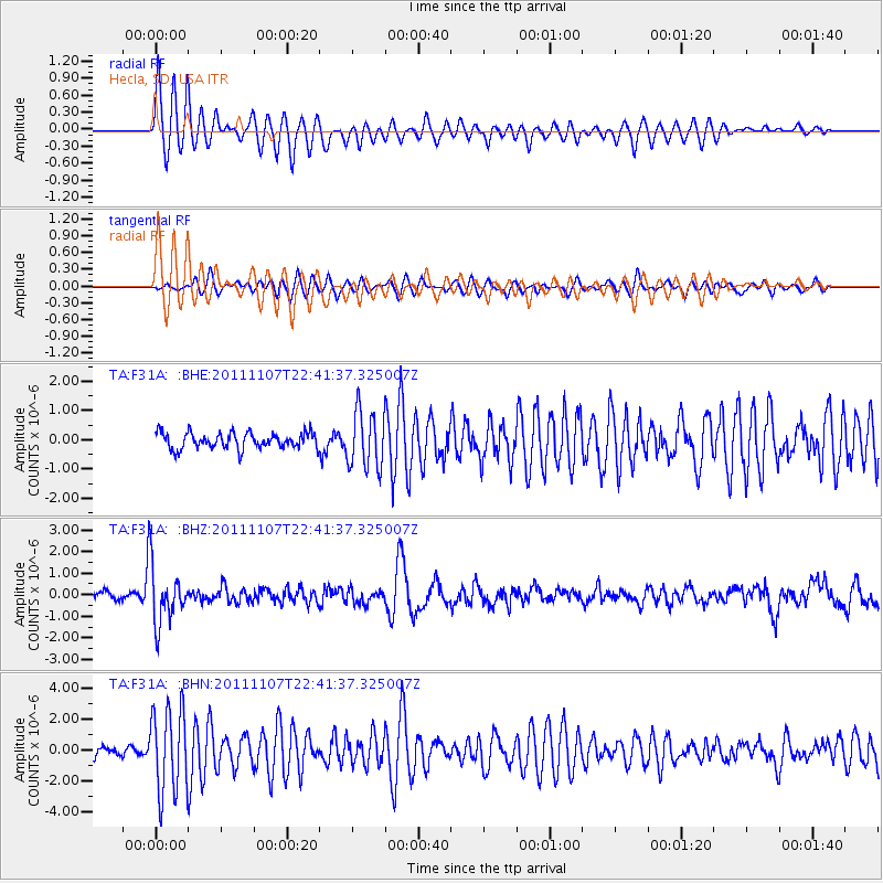
| TA:F31A: :BHZ:20111107T22:41:37.325007Z | 6.8807507 | 1.3291996E-6 | 1.9317653E-7 |
| TA:F31A: :BHN:20111107T22:41:37.325007Z | 7.3630996 | 2.7329918E-6 | 3.7117408E-7 |
| TA:F31A: :BHE:20111107T22:41:37.325007Z | 3.5107148 | 9.673513E-7 | 2.7554256E-7 |
| Arrivals |
| Ps | 4.7 SECOND |
| PpPs | 14 SECOND |
| PsPs/PpSs | 19 SECOND |


