You are here: Home > Network List > TA - USArray Transportable Network (new EarthScope stations) Stations List
> Station F35A Swanville, MN, USA > Earthquake Result Viewer
F35A Swanville, MN, USA - Earthquake Result Viewer

| Earthquake location: |
Nicaragua |
| Earthquake latitude/longitude: |
11.6/-85.9 |
| Earthquake time(UTC): |
2011/11/07 (311) 22:35:25 GMT |
| Earthquake Depth: |
177 km |
| Earthquake Magnitude: |
6.0 MB, 6.0 MW, 6.1 MW |
| Earthquake Catalog/Contributor: |
WHDF/NEIC |
|
| Network: |
TA USArray Transportable Network (new EarthScope stations) |
| Station: |
F35A Swanville, MN, USA |
| Lat/Lon: |
45.86 N/94.57 W |
| Elevation: |
376 m |
|
| Distance: |
35.0 deg |
| Az: |
349.359 deg |
| Baz: |
164.993 deg |
| Ray Param: |
0.076832175 |
| Estimated Moho Depth: |
37.25 km |
| Estimated Crust Vp/Vs: |
1.77 |
| Assumed Crust Vp: |
6.571 km/s |
| Estimated Crust Vs: |
3.707 km/s |
| Estimated Crust Poisson's Ratio: |
0.27 |
|
| Radial Match: |
90.13059 % |
| Radial Bump: |
400 |
| Transverse Match: |
73.458244 % |
| Transverse Bump: |
400 |
| SOD ConfigId: |
424168 |
| Insert Time: |
2012-02-24 05:46:37.500 +0000 |
| GWidth: |
2.5 |
| Max Bumps: |
400 |
| Tol: |
0.001 |
|
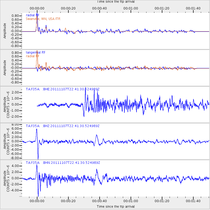
Signal To Noise
| Channel | StoN | STA | LTA |
| TA:F35A: :BHZ:20111107T22:41:30.524989Z | 12.266027 | 2.9349237E-6 | 2.3927254E-7 |
| TA:F35A: :BHN:20111107T22:41:30.524989Z | 14.374037 | 2.2282002E-6 | 1.5501561E-7 |
| TA:F35A: :BHE:20111107T22:41:30.524989Z | 6.701498 | 1.0474441E-6 | 1.5629999E-7 |
| Arrivals |
| Ps | 4.7 SECOND |
| PpPs | 15 SECOND |
| PsPs/PpSs | 19 SECOND |


