You are here: Home > Network List > WI - West Indies IPGP Network Stations List
> Station TDBA Terre de Bas, Les Saintes, Guadeloupe > Earthquake Result Viewer
TDBA Terre de Bas, Les Saintes, Guadeloupe - Earthquake Result Viewer
| Earthquake location: |
Guerrero, Mexico |
| Earthquake latitude/longitude: |
17.6/-100.8 |
| Earthquake time(UTC): |
2014/04/18 (108) 14:27:26 GMT |
| Earthquake Depth: |
24 km |
| Earthquake Magnitude: |
7.2 MWW, 7.0 MWB, 7.3 MWC, 7.5 MI |
| Earthquake Catalog/Contributor: |
NEIC PDE/NEIC COMCAT |
|
| Network: |
WI West Indies IPGP Network |
| Station: |
TDBA Terre de Bas, Les Saintes, Guadeloupe |
| Lat/Lon: |
15.85 N/61.64 W |
| Elevation: |
159 m |
|
| Distance: |
37.5 deg |
| Az: |
86.667 deg |
| Baz: |
278.278 deg |
| Ray Param: |
0.07605475 |
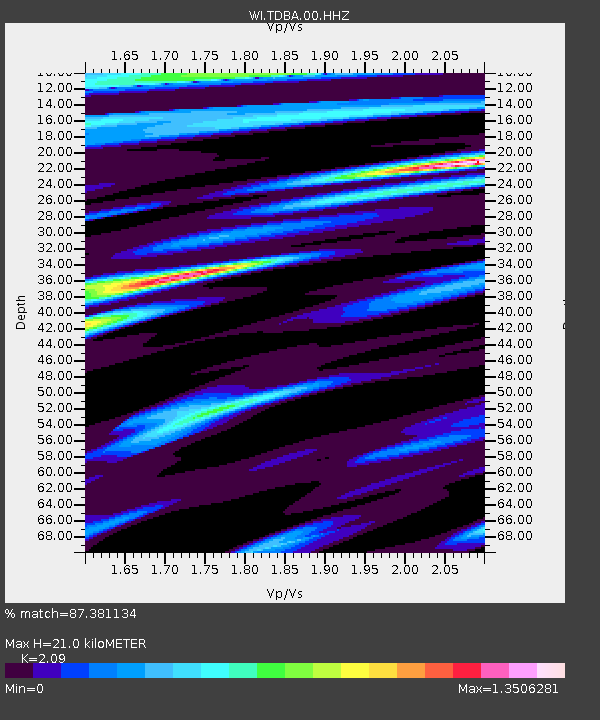
| Estimated Moho Depth: |
21.0 km |
| Estimated Crust Vp/Vs: |
2.09 |
| Assumed Crust Vp: |
5.88 km/s |
| Estimated Crust Vs: |
2.814 km/s |
| Estimated Crust Poisson's Ratio: |
0.35 |
|
| Radial Match: |
87.381134 % |
| Radial Bump: |
338 |
| Transverse Match: |
66.80365 % |
| Transverse Bump: |
400 |
| SOD ConfigId: |
3390531 |
| Insert Time: |
2019-04-11 11:12:35.779 +0000 |
| GWidth: |
2.5 |
| Max Bumps: |
400 |
| Tol: |
0.001 |
|

Signal To Noise
| Channel | StoN | STA | LTA |
| WI:TDBA:00:HHZ:20140418T14:34:07.490005Z | 10.272407 | 9.993775E-6 | 9.728758E-7 |
| WI:TDBA:00:HHN:20140418T14:34:07.490005Z | 1.2512286 | 1.7773559E-6 | 1.4204886E-6 |
| WI:TDBA:00:HHE:20140418T14:34:07.490005Z | 7.0766134 | 6.3248253E-6 | 8.937645E-7 |
| Arrivals |
| Ps | 4.1 SECOND |
| PpPs | 10 SECOND |
| PsPs/PpSs | 15 SECOND |


