You are here: Home > Network List > TA - USArray Transportable Network (new EarthScope stations) Stations List
> Station G35A Watkins, MN, USA > Earthquake Result Viewer
G35A Watkins, MN, USA - Earthquake Result Viewer

| Earthquake location: |
Nicaragua |
| Earthquake latitude/longitude: |
11.6/-85.9 |
| Earthquake time(UTC): |
2011/11/07 (311) 22:35:25 GMT |
| Earthquake Depth: |
177 km |
| Earthquake Magnitude: |
6.0 MB, 6.0 MW, 6.1 MW |
| Earthquake Catalog/Contributor: |
WHDF/NEIC |
|
| Network: |
TA USArray Transportable Network (new EarthScope stations) |
| Station: |
G35A Watkins, MN, USA |
| Lat/Lon: |
45.22 N/94.49 W |
| Elevation: |
361 m |
|
| Distance: |
34.3 deg |
| Az: |
349.173 deg |
| Baz: |
164.902 deg |
| Ray Param: |
0.07717074 |
| Estimated Moho Depth: |
34.25 km |
| Estimated Crust Vp/Vs: |
1.95 |
| Assumed Crust Vp: |
6.571 km/s |
| Estimated Crust Vs: |
3.37 km/s |
| Estimated Crust Poisson's Ratio: |
0.32 |
|
| Radial Match: |
87.045105 % |
| Radial Bump: |
400 |
| Transverse Match: |
68.32836 % |
| Transverse Bump: |
400 |
| SOD ConfigId: |
424168 |
| Insert Time: |
2012-02-24 05:47:05.880 +0000 |
| GWidth: |
2.5 |
| Max Bumps: |
400 |
| Tol: |
0.001 |
|
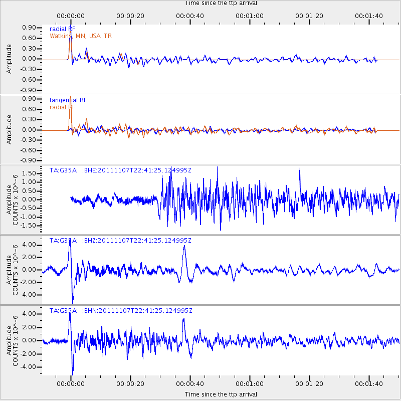
Signal To Noise
| Channel | StoN | STA | LTA |
| TA:G35A: :BHZ:20111107T22:41:25.124995Z | 13.185642 | 2.4500328E-6 | 1.8581063E-7 |
| TA:G35A: :BHN:20111107T22:41:25.124995Z | 10.583521 | 2.0209668E-6 | 1.909541E-7 |
| TA:G35A: :BHE:20111107T22:41:25.124995Z | 4.9434133 | 7.3594606E-7 | 1.4887408E-7 |
| Arrivals |
| Ps | 5.3 SECOND |
| PpPs | 14 SECOND |
| PsPs/PpSs | 20 SECOND |


