You are here: Home > Network List > X812 - Deep Structure of Three Continental Sutures in Eastern North America Stations List
> Station QM15 Land Trust South, Maine, USA > Earthquake Result Viewer
QM15 Land Trust South, Maine, USA - Earthquake Result Viewer
| Earthquake location: |
Guerrero, Mexico |
| Earthquake latitude/longitude: |
17.6/-100.8 |
| Earthquake time(UTC): |
2014/04/18 (108) 14:27:26 GMT |
| Earthquake Depth: |
24 km |
| Earthquake Magnitude: |
7.2 MWW, 7.0 MWB, 7.3 MWC, 7.5 MI |
| Earthquake Catalog/Contributor: |
NEIC PDE/NEIC COMCAT |
|
| Network: |
X8 Deep Structure of Three Continental Sutures in Eastern North America |
| Station: |
QM15 Land Trust South, Maine, USA |
| Lat/Lon: |
45.09 N/67.84 W |
| Elevation: |
151 m |
|
| Distance: |
38.9 deg |
| Az: |
37.895 deg |
| Baz: |
235.819 deg |
| Ray Param: |
0.07527 |
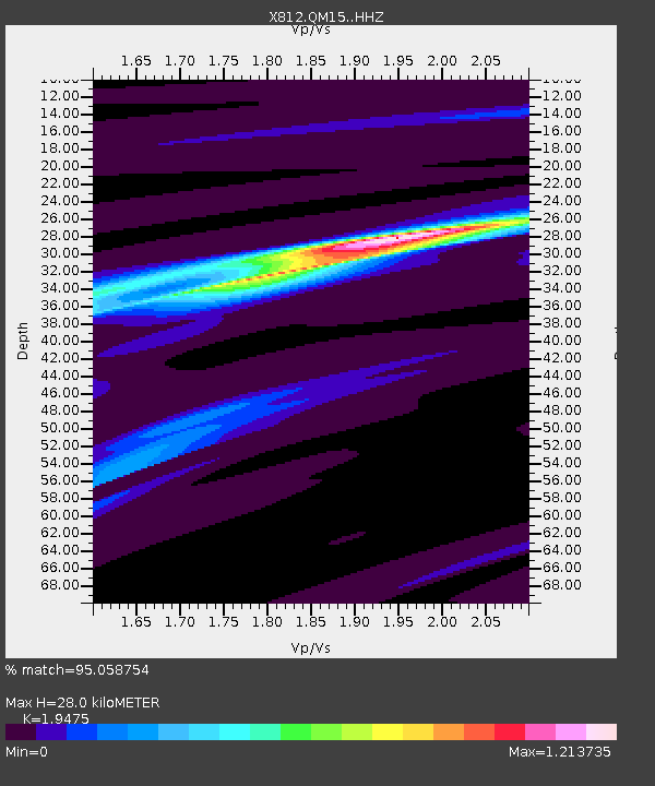
| Estimated Moho Depth: |
28.0 km |
| Estimated Crust Vp/Vs: |
1.95 |
| Assumed Crust Vp: |
6.419 km/s |
| Estimated Crust Vs: |
3.296 km/s |
| Estimated Crust Poisson's Ratio: |
0.32 |
|
| Radial Match: |
95.058754 % |
| Radial Bump: |
169 |
| Transverse Match: |
73.29941 % |
| Transverse Bump: |
400 |
| SOD ConfigId: |
3390531 |
| Insert Time: |
2019-04-11 11:12:46.223 +0000 |
| GWidth: |
2.5 |
| Max Bumps: |
400 |
| Tol: |
0.001 |
|

Signal To Noise
| Channel | StoN | STA | LTA |
| X8:QM15: :HHZ:20140418T14:34:19.740005Z | 34.466167 | 1.1351652E-5 | 3.2935637E-7 |
| X8:QM15: :HHN:20140418T14:34:19.740005Z | 16.388956 | 3.4791206E-6 | 2.1228445E-7 |
| X8:QM15: :HHE:20140418T14:34:19.740005Z | 23.77779 | 6.6943776E-6 | 2.815391E-7 |
| Arrivals |
| Ps | 4.4 SECOND |
| PpPs | 12 SECOND |
| PsPs/PpSs | 16 SECOND |


