You are here: Home > Network List > X812 - Deep Structure of Three Continental Sutures in Eastern North America Stations List
> Station QM31 Togue Pond, Maine, USA > Earthquake Result Viewer
QM31 Togue Pond, Maine, USA - Earthquake Result Viewer
| Earthquake location: |
Guerrero, Mexico |
| Earthquake latitude/longitude: |
17.6/-100.8 |
| Earthquake time(UTC): |
2014/04/18 (108) 14:27:26 GMT |
| Earthquake Depth: |
24 km |
| Earthquake Magnitude: |
7.2 MWW, 7.0 MWB, 7.3 MWC, 7.5 MI |
| Earthquake Catalog/Contributor: |
NEIC PDE/NEIC COMCAT |
|
| Network: |
X8 Deep Structure of Three Continental Sutures in Eastern North America |
| Station: |
QM31 Togue Pond, Maine, USA |
| Lat/Lon: |
46.93 N/68.89 W |
| Elevation: |
0.0 m |
|
| Distance: |
39.4 deg |
| Az: |
34.854 deg |
| Baz: |
232.71 deg |
| Ray Param: |
0.07499116 |
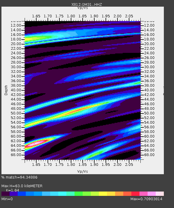
| Estimated Moho Depth: |
63.0 km |
| Estimated Crust Vp/Vs: |
1.64 |
| Assumed Crust Vp: |
6.419 km/s |
| Estimated Crust Vs: |
3.914 km/s |
| Estimated Crust Poisson's Ratio: |
0.20 |
|
| Radial Match: |
94.34886 % |
| Radial Bump: |
332 |
| Transverse Match: |
63.97468 % |
| Transverse Bump: |
400 |
| SOD ConfigId: |
3390531 |
| Insert Time: |
2019-04-11 11:12:49.636 +0000 |
| GWidth: |
2.5 |
| Max Bumps: |
400 |
| Tol: |
0.001 |
|

Signal To Noise
| Channel | StoN | STA | LTA |
| X8:QM31: :HHZ:20140418T14:34:23.759994Z | 47.188503 | 1.1615004E-5 | 2.4614056E-7 |
| X8:QM31: :HHN:20140418T14:34:23.759994Z | 1.7805468 | 5.253712E-6 | 2.9506173E-6 |
| X8:QM31: :HHE:20140418T14:34:23.759994Z | 2.3000715 | 4.6013383E-6 | 2.0005195E-6 |
| Arrivals |
| Ps | 6.8 SECOND |
| PpPs | 24 SECOND |
| PsPs/PpSs | 31 SECOND |


