You are here: Home > Network List > TA - USArray Transportable Network (new EarthScope stations) Stations List
> Station J38A Wedel Dairy, Riceville, IA, USA > Earthquake Result Viewer
J38A Wedel Dairy, Riceville, IA, USA - Earthquake Result Viewer
| Earthquake location: |
Nicaragua |
| Earthquake latitude/longitude: |
11.6/-85.9 |
| Earthquake time(UTC): |
2011/11/07 (311) 22:35:25 GMT |
| Earthquake Depth: |
177 km |
| Earthquake Magnitude: |
6.0 MB, 6.0 MW, 6.1 MW |
| Earthquake Catalog/Contributor: |
WHDF/NEIC |
|
| Network: |
TA USArray Transportable Network (new EarthScope stations) |
| Station: |
J38A Wedel Dairy, Riceville, IA, USA |
| Lat/Lon: |
43.32 N/92.48 W |
| Elevation: |
371 m |
|
| Distance: |
32.2 deg |
| Az: |
350.912 deg |
| Baz: |
167.756 deg |
| Ray Param: |
0.07823646 |
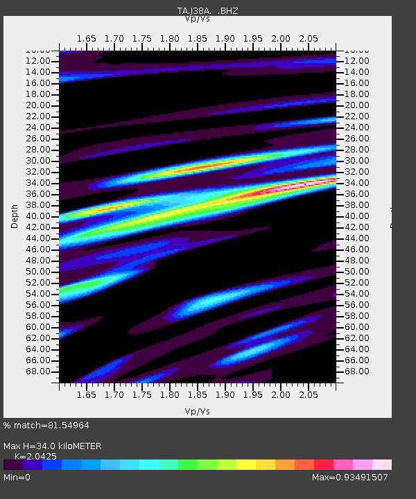
| Estimated Moho Depth: |
34.0 km |
| Estimated Crust Vp/Vs: |
2.04 |
| Assumed Crust Vp: |
6.53 km/s |
| Estimated Crust Vs: |
3.197 km/s |
| Estimated Crust Poisson's Ratio: |
0.34 |
|
| Radial Match: |
81.54964 % |
| Radial Bump: |
339 |
| Transverse Match: |
83.567276 % |
| Transverse Bump: |
400 |
| SOD ConfigId: |
424168 |
| Insert Time: |
2012-02-24 05:48:49.022 +0000 |
| GWidth: |
2.5 |
| Max Bumps: |
400 |
| Tol: |
0.001 |
|
Signal To Noise
| Channel | StoN | STA | LTA |
| TA:J38A: :BHZ:20111107T22:41:06.225001Z | 24.025585 | 4.842992E-6 | 2.0157644E-7 |
| TA:J38A: :BHN:20111107T22:41:06.225001Z | 10.674055 | 2.1301396E-6 | 1.9956236E-7 |
| TA:J38A: :BHE:20111107T22:41:06.225001Z | 5.7058415 | 1.0902532E-6 | 1.9107668E-7 |
| Arrivals |
| Ps | 5.8 SECOND |
| PpPs | 15 SECOND |
| PsPs/PpSs | 21 SECOND |


