You are here: Home > Network List > X812 - Deep Structure of Three Continental Sutures in Eastern North America Stations List
> Station QM80 Route du Nord, Quebec, Canada > Earthquake Result Viewer
QM80 Route du Nord, Quebec, Canada - Earthquake Result Viewer
| Earthquake location: |
Guerrero, Mexico |
| Earthquake latitude/longitude: |
17.6/-100.8 |
| Earthquake time(UTC): |
2014/04/18 (108) 14:27:26 GMT |
| Earthquake Depth: |
24 km |
| Earthquake Magnitude: |
7.2 MWW, 7.0 MWB, 7.3 MWC, 7.5 MI |
| Earthquake Catalog/Contributor: |
NEIC PDE/NEIC COMCAT |
|
| Network: |
X8 Deep Structure of Three Continental Sutures in Eastern North America |
| Station: |
QM80 Route du Nord, Quebec, Canada |
| Lat/Lon: |
50.96 N/75.23 W |
| Elevation: |
371 m |
|
| Distance: |
39.1 deg |
| Az: |
25.676 deg |
| Baz: |
220.821 deg |
| Ray Param: |
0.07515556 |
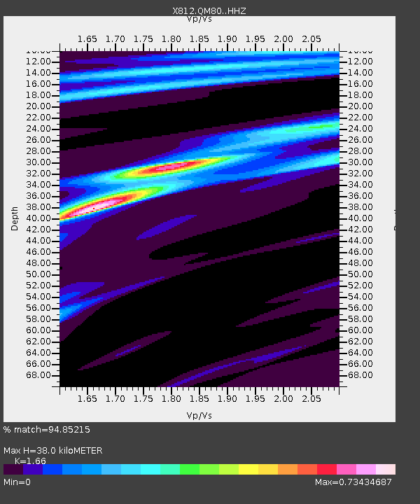
| Estimated Moho Depth: |
38.0 km |
| Estimated Crust Vp/Vs: |
1.66 |
| Assumed Crust Vp: |
6.61 km/s |
| Estimated Crust Vs: |
3.982 km/s |
| Estimated Crust Poisson's Ratio: |
0.22 |
|
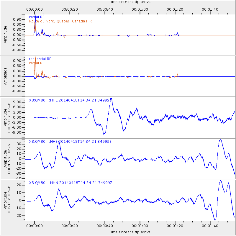
| Radial Match: |
94.85215 % |
| Radial Bump: |
136 |
| Transverse Match: |
84.78451 % |
| Transverse Bump: |
400 |
| SOD ConfigId: |
3390531 |
| Insert Time: |
2019-04-11 11:12:57.137 +0000 |
| GWidth: |
2.5 |
| Max Bumps: |
400 |
| Tol: |
0.001 |
|
Signal To Noise
| Channel | StoN | STA | LTA |
| X8:QM80: :HHZ:20140418T14:34:21.34999Z | 80.89535 | 8.563447E-6 | 1.0585834E-7 |
| X8:QM80: :HHN:20140418T14:34:21.34999Z | 33.482147 | 4.3192285E-6 | 1.2900095E-7 |
| X8:QM80: :HHE:20140418T14:34:21.34999Z | 12.524641 | 2.7830856E-6 | 2.2220881E-7 |
| Arrivals |
| Ps | 4.1 SECOND |
| PpPs | 14 SECOND |
| PsPs/PpSs | 18 SECOND |


