You are here: Home > Network List > TA - USArray Transportable Network (new EarthScope stations) Stations List
> Station A32A Rocking H Ranch, Lancaster, MN, USA > Earthquake Result Viewer
A32A Rocking H Ranch, Lancaster, MN, USA - Earthquake Result Viewer
| Earthquake location: |
Nicaragua |
| Earthquake latitude/longitude: |
11.6/-85.9 |
| Earthquake time(UTC): |
2011/11/07 (311) 22:35:25 GMT |
| Earthquake Depth: |
177 km |
| Earthquake Magnitude: |
6.0 MB, 6.0 MW, 6.1 MW |
| Earthquake Catalog/Contributor: |
WHDF/NEIC |
|
| Network: |
TA USArray Transportable Network (new EarthScope stations) |
| Station: |
A32A Rocking H Ranch, Lancaster, MN, USA |
| Lat/Lon: |
48.92 N/96.49 W |
| Elevation: |
322 m |
|
| Distance: |
38.3 deg |
| Az: |
348.67 deg |
| Baz: |
163.03 deg |
| Ray Param: |
0.0749967 |
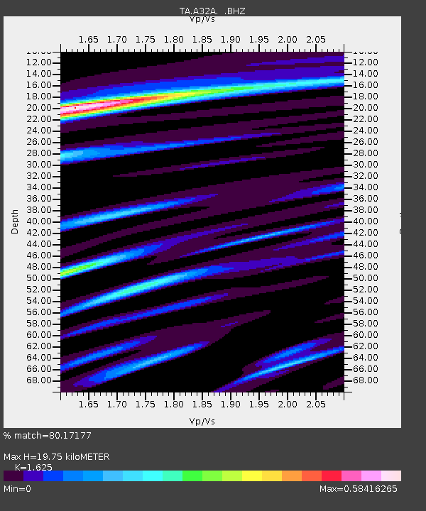
| Estimated Moho Depth: |
19.75 km |
| Estimated Crust Vp/Vs: |
1.62 |
| Assumed Crust Vp: |
6.498 km/s |
| Estimated Crust Vs: |
3.998 km/s |
| Estimated Crust Poisson's Ratio: |
0.20 |
|
| Radial Match: |
80.17177 % |
| Radial Bump: |
285 |
| Transverse Match: |
56.938732 % |
| Transverse Bump: |
400 |
| SOD ConfigId: |
424168 |
| Insert Time: |
2012-02-24 05:49:15.521 +0000 |
| GWidth: |
2.5 |
| Max Bumps: |
400 |
| Tol: |
0.001 |
|

Signal To Noise
| Channel | StoN | STA | LTA |
| TA:A32A: :BHZ:20111107T22:41:58.374995Z | 10.737912 | 1.7435945E-6 | 1.6237742E-7 |
| TA:A32A: :BHN:20111107T22:41:58.374995Z | 7.9119306 | 1.2135445E-6 | 1.5338159E-7 |
| TA:A32A: :BHE:20111107T22:41:58.374995Z | 3.5615466 | 4.1216143E-7 | 1.15725406E-7 |
| Arrivals |
| Ps | 2.1 SECOND |
| PpPs | 7.4 SECOND |
| PsPs/PpSs | 9.4 SECOND |


