You are here: Home > Network List > X812 - Deep Structure of Three Continental Sutures in Eastern North America Stations List
> Station QMPO Pohenegamook, Quebec, Canada > Earthquake Result Viewer
QMPO Pohenegamook, Quebec, Canada - Earthquake Result Viewer
| Earthquake location: |
Guerrero, Mexico |
| Earthquake latitude/longitude: |
17.6/-100.8 |
| Earthquake time(UTC): |
2014/04/18 (108) 14:27:26 GMT |
| Earthquake Depth: |
24 km |
| Earthquake Magnitude: |
7.2 MWW, 7.0 MWB, 7.3 MWC, 7.5 MI |
| Earthquake Catalog/Contributor: |
NEIC PDE/NEIC COMCAT |
|
| Network: |
X8 Deep Structure of Three Continental Sutures in Eastern North America |
| Station: |
QMPO Pohenegamook, Quebec, Canada |
| Lat/Lon: |
47.53 N/69.36 W |
| Elevation: |
430 m |
|
| Distance: |
39.5 deg |
| Az: |
33.793 deg |
| Baz: |
231.542 deg |
| Ray Param: |
0.07492577 |
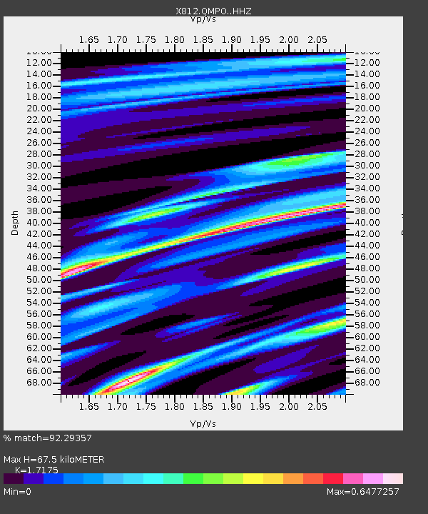
| Estimated Moho Depth: |
67.5 km |
| Estimated Crust Vp/Vs: |
1.72 |
| Assumed Crust Vp: |
6.419 km/s |
| Estimated Crust Vs: |
3.738 km/s |
| Estimated Crust Poisson's Ratio: |
0.24 |
|
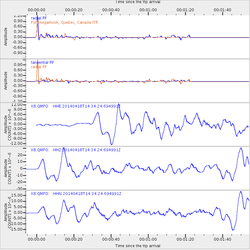
| Radial Match: |
92.29357 % |
| Radial Bump: |
324 |
| Transverse Match: |
66.00562 % |
| Transverse Bump: |
400 |
| SOD ConfigId: |
3390531 |
| Insert Time: |
2019-04-11 11:13:00.528 +0000 |
| GWidth: |
2.5 |
| Max Bumps: |
400 |
| Tol: |
0.001 |
|
Signal To Noise
| Channel | StoN | STA | LTA |
| X8:QMPO: :HHZ:20140418T14:34:24.694991Z | 17.019638 | 7.3588417E-6 | 4.323736E-7 |
| X8:QMPO: :HHN:20140418T14:34:24.694991Z | 15.1772585 | 3.0469062E-6 | 2.0075471E-7 |
| X8:QMPO: :HHE:20140418T14:34:24.694991Z | 9.310833 | 4.29444E-6 | 4.6123046E-7 |
| Arrivals |
| Ps | 8.1 SECOND |
| PpPs | 27 SECOND |
| PsPs/PpSs | 35 SECOND |


