You are here: Home > Network List > TA - USArray Transportable Network (new EarthScope stations) Stations List
> Station M39A Webster, IA, USA > Earthquake Result Viewer
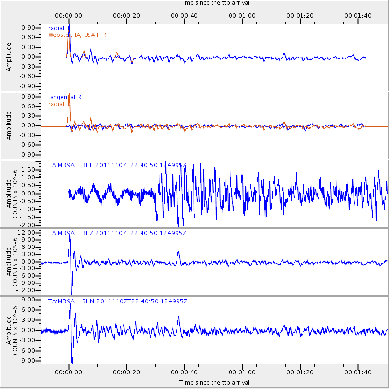
M39A Webster, IA, USA - Earthquake Result Viewer

| Earthquake location: |
Nicaragua |
| Earthquake latitude/longitude: |
11.6/-85.9 |
| Earthquake time(UTC): |
2011/11/07 (311) 22:35:25 GMT |
| Earthquake Depth: |
177 km |
| Earthquake Magnitude: |
6.0 MB, 6.0 MW, 6.1 MW |
| Earthquake Catalog/Contributor: |
WHDF/NEIC |
|
| Network: |
TA USArray Transportable Network (new EarthScope stations) |
| Station: |
M39A Webster, IA, USA |
| Lat/Lon: |
41.48 N/92.17 W |
| Elevation: |
264 m |
|
| Distance: |
30.3 deg |
| Az: |
350.581 deg |
| Baz: |
167.676 deg |
| Ray Param: |
0.07902891 |
| Estimated Moho Depth: |
21.25 km |
| Estimated Crust Vp/Vs: |
1.62 |
| Assumed Crust Vp: |
6.498 km/s |
| Estimated Crust Vs: |
4.005 km/s |
| Estimated Crust Poisson's Ratio: |
0.19 |
|
| Radial Match: |
93.80956 % |
| Radial Bump: |
345 |
| Transverse Match: |
75.04336 % |
| Transverse Bump: |
400 |
| SOD ConfigId: |
424168 |
| Insert Time: |
2012-02-24 05:51:02.628 +0000 |
| GWidth: |
2.5 |
| Max Bumps: |
400 |
| Tol: |
0.001 |
|
Signal To Noise
| Channel | StoN | STA | LTA |
| TA:M39A: :BHZ:20111107T22:40:50.124995Z | 25.394485 | 5.126958E-6 | 2.0189259E-7 |
| TA:M39A: :BHN:20111107T22:40:50.124995Z | 15.560139 | 3.970797E-6 | 2.5519034E-7 |
| TA:M39A: :BHE:20111107T22:40:50.124995Z | 3.2645924 | 8.8816637E-7 | 2.7206042E-7 |
| Arrivals |
| Ps | 2.2 SECOND |
| PpPs | 7.8 SECOND |
| PsPs/PpSs | 10 SECOND |


