You are here: Home > Network List > TA - USArray Transportable Network (new EarthScope stations) Stations List
> Station I39A Houston, MN, USA > Earthquake Result Viewer
I39A Houston, MN, USA - Earthquake Result Viewer

| Earthquake location: |
Nicaragua |
| Earthquake latitude/longitude: |
11.6/-85.9 |
| Earthquake time(UTC): |
2011/11/07 (311) 22:35:25 GMT |
| Earthquake Depth: |
177 km |
| Earthquake Magnitude: |
6.0 MB, 6.0 MW, 6.1 MW |
| Earthquake Catalog/Contributor: |
WHDF/NEIC |
|
| Network: |
TA USArray Transportable Network (new EarthScope stations) |
| Station: |
I39A Houston, MN, USA |
| Lat/Lon: |
43.85 N/91.52 W |
| Elevation: |
393 m |
|
| Distance: |
32.5 deg |
| Az: |
352.376 deg |
| Baz: |
169.647 deg |
| Ray Param: |
0.07805937 |
| Estimated Moho Depth: |
44.75 km |
| Estimated Crust Vp/Vs: |
1.68 |
| Assumed Crust Vp: |
6.53 km/s |
| Estimated Crust Vs: |
3.893 km/s |
| Estimated Crust Poisson's Ratio: |
0.22 |
|
| Radial Match: |
88.647446 % |
| Radial Bump: |
400 |
| Transverse Match: |
77.22681 % |
| Transverse Bump: |
400 |
| SOD ConfigId: |
424168 |
| Insert Time: |
2012-02-24 05:51:55.312 +0000 |
| GWidth: |
2.5 |
| Max Bumps: |
400 |
| Tol: |
0.001 |
|
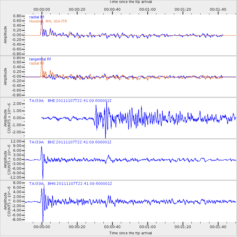
Signal To Noise
| Channel | StoN | STA | LTA |
| TA:I39A: :BHZ:20111107T22:41:09.600001Z | 21.60922 | 3.9423758E-6 | 1.8243952E-7 |
| TA:I39A: :BHN:20111107T22:41:09.600001Z | 20.712933 | 3.1669776E-6 | 1.5289856E-7 |
| TA:I39A: :BHE:20111107T22:41:09.600001Z | 6.4755216 | 7.717796E-7 | 1.19184165E-7 |
| Arrivals |
| Ps | 5.1 SECOND |
| PpPs | 17 SECOND |
| PsPs/PpSs | 22 SECOND |


