You are here: Home > Network List > G - GEOSCOPE Stations List
> Station HYB Hyderabad, India > Earthquake Result Viewer
HYB Hyderabad, India - Earthquake Result Viewer

| Earthquake location: |
Santa Cruz Islands |
| Earthquake latitude/longitude: |
-11.0/165.2 |
| Earthquake time(UTC): |
1992/05/27 (148) 05:13:41 GMT |
| Earthquake Depth: |
33 km |
| Earthquake Magnitude: |
6.3 MB, 7.0 MS, 7.3 UNKNOWN |
| Earthquake Catalog/Contributor: |
WHDF/NEIC |
|
| Network: |
G GEOSCOPE |
| Station: |
HYB Hyderabad, India |
| Lat/Lon: |
17.42 N/78.55 E |
| Elevation: |
510 m |
|
| Distance: |
90.1 deg |
| Az: |
287.622 deg |
| Baz: |
101.463 deg |
| Ray Param: |
0.041694444 |
| Estimated Moho Depth: |
34.5 km |
| Estimated Crust Vp/Vs: |
1.67 |
| Assumed Crust Vp: |
6.459 km/s |
| Estimated Crust Vs: |
3.868 km/s |
| Estimated Crust Poisson's Ratio: |
0.22 |
|
| Radial Match: |
97.130936 % |
| Radial Bump: |
335 |
| Transverse Match: |
85.77547 % |
| Transverse Bump: |
400 |
| SOD ConfigId: |
16938 |
| Insert Time: |
2010-02-26 22:47:51.111 +0000 |
| GWidth: |
2.5 |
| Max Bumps: |
400 |
| Tol: |
0.001 |
|
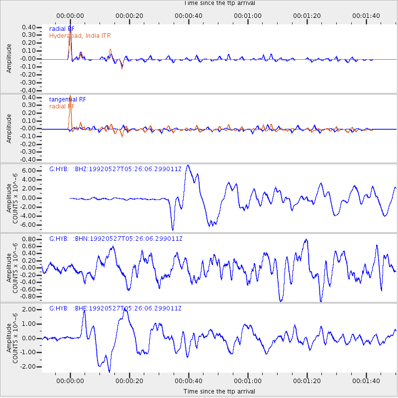
Signal To Noise
| Channel | StoN | STA | LTA |
| G:HYB: :BHN:19920527T05:26:06.299011Z | 1.4294354 | 1.2517786E-7 | 8.7571536E-8 |
| G:HYB: :BHE:19920527T05:26:06.299011Z | 9.019688 | 7.0180647E-7 | 7.780829E-8 |
| G:HYB: :BHZ:19920527T05:26:06.299011Z | 18.099916 | 2.3788934E-6 | 1.3143118E-7 |
| Arrivals |
| Ps | 3.7 SECOND |
| PpPs | 14 SECOND |
| PsPs/PpSs | 18 SECOND |


