You are here: Home > Network List > TA - USArray Transportable Network (new EarthScope stations) Stations List
> Station F43A Flat Rock, Escanaba, MI, USA > Earthquake Result Viewer
F43A Flat Rock, Escanaba, MI, USA - Earthquake Result Viewer
| Earthquake location: |
Nicaragua |
| Earthquake latitude/longitude: |
11.6/-85.9 |
| Earthquake time(UTC): |
2011/11/07 (311) 22:35:25 GMT |
| Earthquake Depth: |
177 km |
| Earthquake Magnitude: |
6.0 MB, 6.0 MW, 6.1 MW |
| Earthquake Catalog/Contributor: |
WHDF/NEIC |
|
| Network: |
TA USArray Transportable Network (new EarthScope stations) |
| Station: |
F43A Flat Rock, Escanaba, MI, USA |
| Lat/Lon: |
45.83 N/87.17 W |
| Elevation: |
233 m |
|
| Distance: |
34.2 deg |
| Az: |
358.371 deg |
| Baz: |
177.717 deg |
| Ray Param: |
0.07726274 |
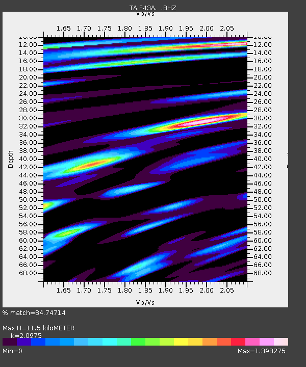
| Estimated Moho Depth: |
11.5 km |
| Estimated Crust Vp/Vs: |
2.10 |
| Assumed Crust Vp: |
6.53 km/s |
| Estimated Crust Vs: |
3.113 km/s |
| Estimated Crust Poisson's Ratio: |
0.35 |
|
| Radial Match: |
84.74714 % |
| Radial Bump: |
400 |
| Transverse Match: |
69.39368 % |
| Transverse Bump: |
400 |
| SOD ConfigId: |
424168 |
| Insert Time: |
2012-02-24 05:54:23.958 +0000 |
| GWidth: |
2.5 |
| Max Bumps: |
400 |
| Tol: |
0.001 |
|

Signal To Noise
| Channel | StoN | STA | LTA |
| TA:F43A: :BHZ:20111107T22:41:23.624995Z | 11.934365 | 3.1112736E-6 | 2.606987E-7 |
| TA:F43A: :BHN:20111107T22:41:23.624995Z | 12.928147 | 2.9652756E-6 | 2.2936585E-7 |
| TA:F43A: :BHE:20111107T22:41:23.624995Z | 1.497873 | 4.6498644E-7 | 3.1043118E-7 |
| Arrivals |
| Ps | 2.1 SECOND |
| PpPs | 5.1 SECOND |
| PsPs/PpSs | 7.2 SECOND |


