You are here: Home > Network List > TA - USArray Transportable Network (new EarthScope stations) Stations List
> Station K42A Prairie Point, Evansville, WI, USA > Earthquake Result Viewer
K42A Prairie Point, Evansville, WI, USA - Earthquake Result Viewer
| Earthquake location: |
Nicaragua |
| Earthquake latitude/longitude: |
11.6/-85.9 |
| Earthquake time(UTC): |
2011/11/07 (311) 22:35:25 GMT |
| Earthquake Depth: |
177 km |
| Earthquake Magnitude: |
6.0 MB, 6.0 MW, 6.1 MW |
| Earthquake Catalog/Contributor: |
WHDF/NEIC |
|
| Network: |
TA USArray Transportable Network (new EarthScope stations) |
| Station: |
K42A Prairie Point, Evansville, WI, USA |
| Lat/Lon: |
42.78 N/89.35 W |
| Elevation: |
302 m |
|
| Distance: |
31.3 deg |
| Az: |
355.051 deg |
| Baz: |
173.407 deg |
| Ray Param: |
0.078634925 |
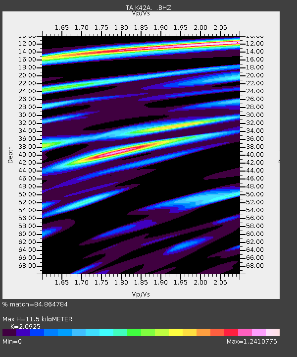
| Estimated Moho Depth: |
11.5 km |
| Estimated Crust Vp/Vs: |
2.09 |
| Assumed Crust Vp: |
6.571 km/s |
| Estimated Crust Vs: |
3.14 km/s |
| Estimated Crust Poisson's Ratio: |
0.35 |
|
| Radial Match: |
84.864784 % |
| Radial Bump: |
400 |
| Transverse Match: |
66.56867 % |
| Transverse Bump: |
400 |
| SOD ConfigId: |
424168 |
| Insert Time: |
2012-02-24 05:55:42.496 +0000 |
| GWidth: |
2.5 |
| Max Bumps: |
400 |
| Tol: |
0.001 |
|
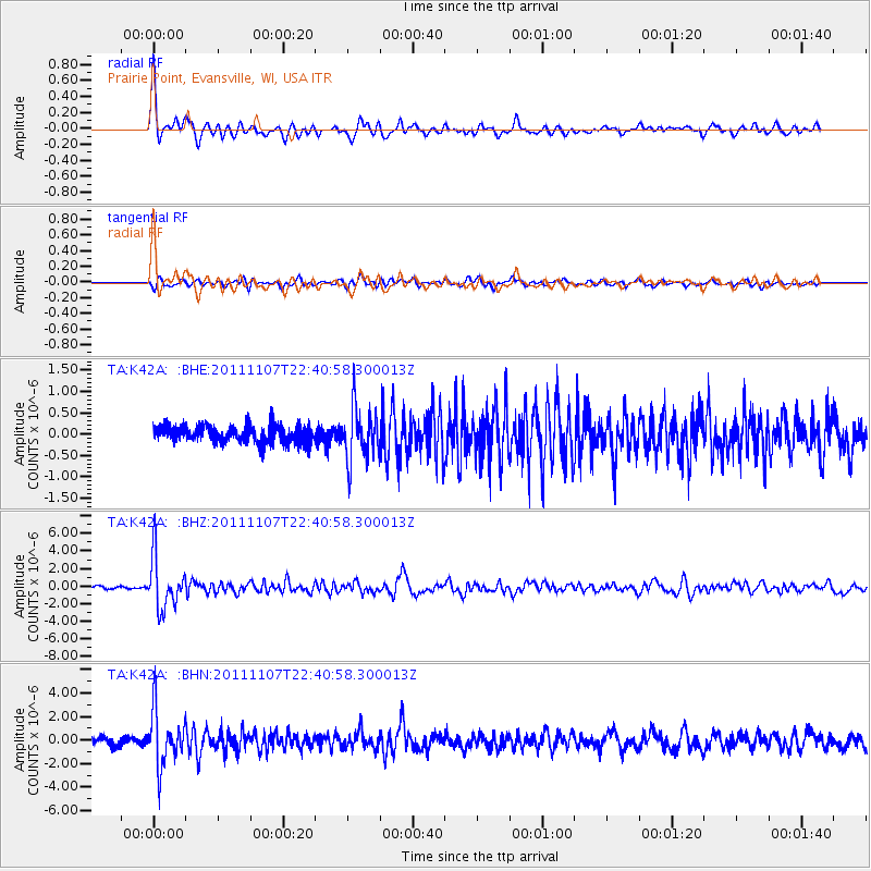
Signal To Noise
| Channel | StoN | STA | LTA |
| TA:K42A: :BHZ:20111107T22:40:58.300013Z | 18.34008 | 2.927015E-6 | 1.5959662E-7 |
| TA:K42A: :BHN:20111107T22:40:58.300013Z | 6.6708946 | 2.3142554E-6 | 3.469183E-7 |
| TA:K42A: :BHE:20111107T22:40:58.300013Z | 3.1583805 | 6.1688485E-7 | 1.9531683E-7 |
| Arrivals |
| Ps | 2.1 SECOND |
| PpPs | 5.0 SECOND |
| PsPs/PpSs | 7.1 SECOND |


