You are here: Home > Network List > G - GEOSCOPE Stations List
> Station HYB Hyderabad, India > Earthquake Result Viewer
HYB Hyderabad, India - Earthquake Result Viewer
| Earthquake location: |
Off East Coast Of Honshu, Japan |
| Earthquake latitude/longitude: |
39.4/143.4 |
| Earthquake time(UTC): |
1992/07/18 (200) 08:36:59 GMT |
| Earthquake Depth: |
33 km |
| Earthquake Magnitude: |
6.1 MB, 6.9 MS |
| Earthquake Catalog/Contributor: |
WHDF/NEIC |
|
| Network: |
G GEOSCOPE |
| Station: |
HYB Hyderabad, India |
| Lat/Lon: |
17.42 N/78.55 E |
| Elevation: |
510 m |
|
| Distance: |
59.8 deg |
| Az: |
268.282 deg |
| Baz: |
54.257 deg |
| Ray Param: |
0.061884068 |
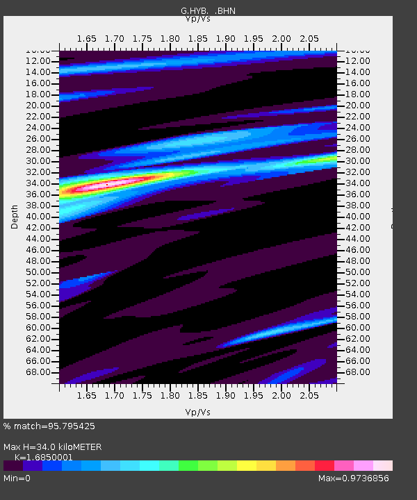
| Estimated Moho Depth: |
34.0 km |
| Estimated Crust Vp/Vs: |
1.69 |
| Assumed Crust Vp: |
6.459 km/s |
| Estimated Crust Vs: |
3.834 km/s |
| Estimated Crust Poisson's Ratio: |
0.23 |
|
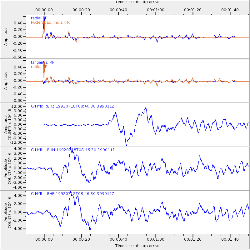
| Radial Match: |
95.795425 % |
| Radial Bump: |
282 |
| Transverse Match: |
71.12497 % |
| Transverse Bump: |
400 |
| SOD ConfigId: |
16938 |
| Insert Time: |
2010-02-26 22:47:55.436 +0000 |
| GWidth: |
2.5 |
| Max Bumps: |
400 |
| Tol: |
0.001 |
|
Signal To Noise
| Channel | StoN | STA | LTA |
| G:HYB: :BHN:19920718T08:46:30.399011Z | 1.0907449 | 2.483655E-7 | 2.2770266E-7 |
| G:HYB: :BHE:19920718T08:46:30.399011Z | 2.0298069 | 4.6159994E-7 | 2.2741078E-7 |
| G:HYB: :BHZ:19920718T08:46:30.399011Z | 1.68156 | 4.9275803E-7 | 2.9303627E-7 |
| Arrivals |
| Ps | 3.8 SECOND |
| PpPs | 13 SECOND |
| PsPs/PpSs | 17 SECOND |


