You are here: Home > Network List > TA - USArray Transportable Network (new EarthScope stations) Stations List
> Station J42A Columbus, WI, USA > Earthquake Result Viewer
J42A Columbus, WI, USA - Earthquake Result Viewer
| Earthquake location: |
Nicaragua |
| Earthquake latitude/longitude: |
11.6/-85.9 |
| Earthquake time(UTC): |
2011/11/07 (311) 22:35:25 GMT |
| Earthquake Depth: |
177 km |
| Earthquake Magnitude: |
6.0 MB, 6.0 MW, 6.1 MW |
| Earthquake Catalog/Contributor: |
WHDF/NEIC |
|
| Network: |
TA USArray Transportable Network (new EarthScope stations) |
| Station: |
J42A Columbus, WI, USA |
| Lat/Lon: |
43.32 N/89.12 W |
| Elevation: |
313 m |
|
| Distance: |
31.8 deg |
| Az: |
355.475 deg |
| Baz: |
173.919 deg |
| Ray Param: |
0.078414954 |
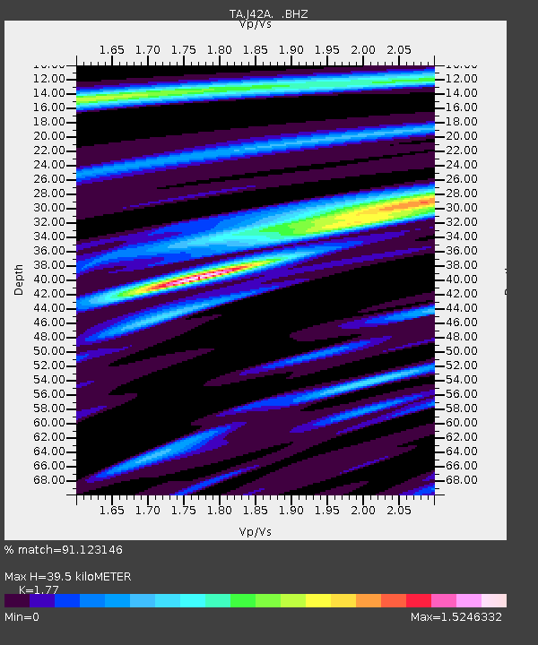
| Estimated Moho Depth: |
39.5 km |
| Estimated Crust Vp/Vs: |
1.77 |
| Assumed Crust Vp: |
6.571 km/s |
| Estimated Crust Vs: |
3.712 km/s |
| Estimated Crust Poisson's Ratio: |
0.27 |
|
| Radial Match: |
91.123146 % |
| Radial Bump: |
335 |
| Transverse Match: |
74.30607 % |
| Transverse Bump: |
400 |
| SOD ConfigId: |
424168 |
| Insert Time: |
2012-02-24 05:55:43.508 +0000 |
| GWidth: |
2.5 |
| Max Bumps: |
400 |
| Tol: |
0.001 |
|

Signal To Noise
| Channel | StoN | STA | LTA |
| TA:J42A: :BHZ:20111107T22:41:02.825007Z | 20.598425 | 4.9178625E-6 | 2.3874944E-7 |
| TA:J42A: :BHN:20111107T22:41:02.825007Z | 19.278889 | 3.3679257E-6 | 1.7469502E-7 |
| TA:J42A: :BHE:20111107T22:41:02.825007Z | 5.0868464 | 6.950969E-7 | 1.3664594E-7 |
| Arrivals |
| Ps | 5.0 SECOND |
| PpPs | 15 SECOND |
| PsPs/PpSs | 20 SECOND |


