You are here: Home > Network List > UW - Pacific Northwest Regional Seismic Network Stations List
> Station LEBA Lebam, WA, USA > Earthquake Result Viewer
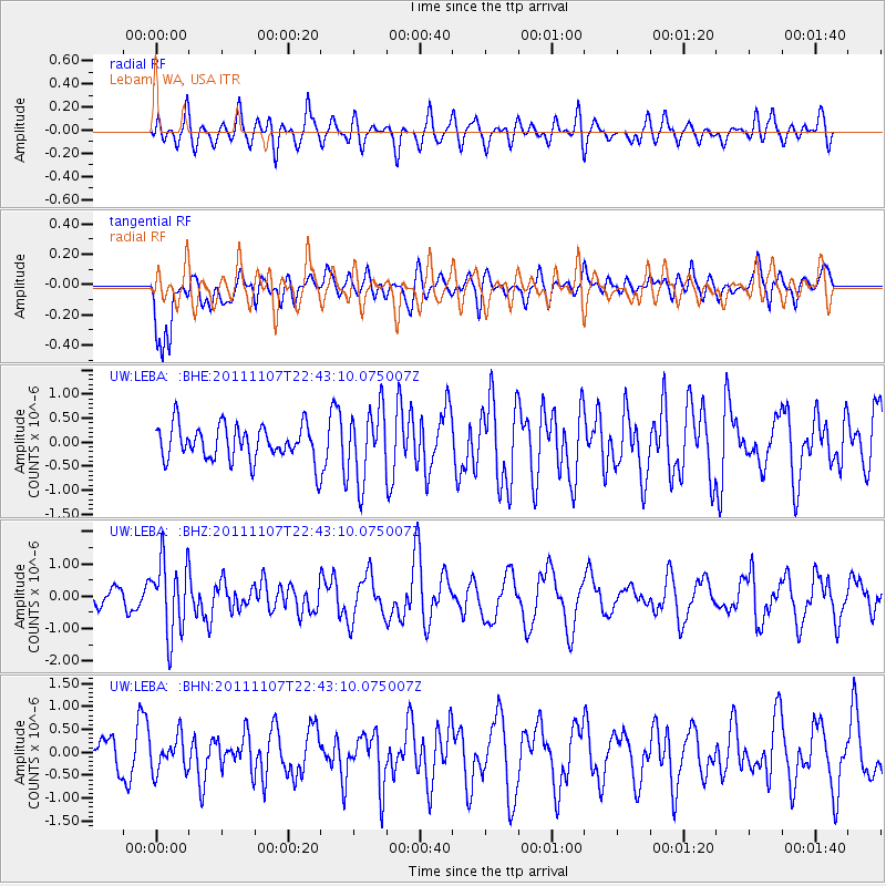
LEBA Lebam, WA, USA - Earthquake Result Viewer
*The percent match for this event was below the threshold and hence no stack was calculated.
| Earthquake location: |
Nicaragua |
| Earthquake latitude/longitude: |
11.6/-85.9 |
| Earthquake time(UTC): |
2011/11/07 (311) 22:35:25 GMT |
| Earthquake Depth: |
177 km |
| Earthquake Magnitude: |
6.0 MB, 6.0 MW, 6.1 MW |
| Earthquake Catalog/Contributor: |
WHDF/NEIC |
|
| Network: |
UW Pacific Northwest Regional Seismic Network |
| Station: |
LEBA Lebam, WA, USA |
| Lat/Lon: |
46.55 N/123.56 W |
| Elevation: |
73 m |
|
| Distance: |
47.2 deg |
| Az: |
324.891 deg |
| Baz: |
125.255 deg |
| Ray Param: |
$rayparam |
*The percent match for this event was below the threshold and hence was not used in the summary stack. |
|
| Radial Match: |
60.678654 % |
| Radial Bump: |
400 |
| Transverse Match: |
65.290955 % |
| Transverse Bump: |
400 |
| SOD ConfigId: |
424168 |
| Insert Time: |
2012-02-24 05:57:31.441 +0000 |
| GWidth: |
2.5 |
| Max Bumps: |
400 |
| Tol: |
0.001 |
|
Signal To Noise
| Channel | StoN | STA | LTA |
| UW:LEBA: :BHZ:20111107T22:43:10.075007Z | 2.458318 | 1.1257129E-6 | 4.5791992E-7 |
| UW:LEBA: :BHN:20111107T22:43:10.075007Z | 0.87682647 | 3.754334E-7 | 4.2817297E-7 |
| UW:LEBA: :BHE:20111107T22:43:10.075007Z | 2.0333753 | 7.340209E-7 | 3.6098643E-7 |
| Arrivals |
| Ps | |
| PpPs | |
| PsPs/PpSs | |


