You are here: Home > Network List > AT - Alaska Tsunami Warning Seismic System Stations List
> Station SMY Shemya, Alaska > Earthquake Result Viewer
SMY Shemya, Alaska - Earthquake Result Viewer
| Earthquake location: |
Northeast Of Taiwan |
| Earthquake latitude/longitude: |
27.3/125.6 |
| Earthquake time(UTC): |
2011/11/08 (312) 02:59:08 GMT |
| Earthquake Depth: |
225 km |
| Earthquake Magnitude: |
6.5 MB, 6.9 MW, 6.9 MW |
| Earthquake Catalog/Contributor: |
WHDF/NEIC |
|
| Network: |
AT Alaska Tsunami Warning Seismic System |
| Station: |
SMY Shemya, Alaska |
| Lat/Lon: |
52.73 N/174.10 E |
| Elevation: |
58 m |
|
| Distance: |
43.9 deg |
| Az: |
41.087 deg |
| Baz: |
254.043 deg |
| Ray Param: |
0.071401134 |
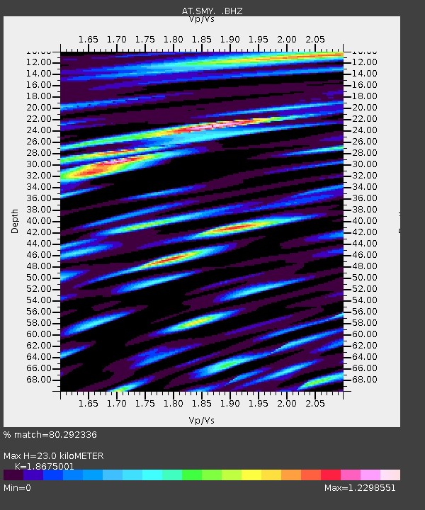
| Estimated Moho Depth: |
23.0 km |
| Estimated Crust Vp/Vs: |
1.87 |
| Assumed Crust Vp: |
3.999 km/s |
| Estimated Crust Vs: |
2.141 km/s |
| Estimated Crust Poisson's Ratio: |
0.30 |
|
| Radial Match: |
80.292336 % |
| Radial Bump: |
400 |
| Transverse Match: |
63.10257 % |
| Transverse Bump: |
400 |
| SOD ConfigId: |
424168 |
| Insert Time: |
2012-02-24 06:06:14.310 +0000 |
| GWidth: |
2.5 |
| Max Bumps: |
400 |
| Tol: |
0.001 |
|

Signal To Noise
| Channel | StoN | STA | LTA |
| AT:SMY: :BHZ:20111108T03:06:21.849996Z | 8.115718 | 7.933172E-6 | 9.775072E-7 |
| AT:SMY: :BHN:20111108T03:06:21.849996Z | 0.6401465 | 9.4453725E-7 | 1.4755018E-6 |
| AT:SMY: :BHE:20111108T03:06:21.849996Z | 3.2286477 | 4.3032933E-6 | 1.332847E-6 |
| Arrivals |
| Ps | 5.1 SECOND |
| PpPs | 16 SECOND |
| PsPs/PpSs | 21 SECOND |


