You are here: Home > Network List > AV - Alaska Volcano Observatory Stations List
> Station SPCG Mount Spurr - Capps Glacier > Earthquake Result Viewer
SPCG Mount Spurr - Capps Glacier - Earthquake Result Viewer
| Earthquake location: |
Northeast Of Taiwan |
| Earthquake latitude/longitude: |
27.3/125.6 |
| Earthquake time(UTC): |
2011/11/08 (312) 02:59:08 GMT |
| Earthquake Depth: |
225 km |
| Earthquake Magnitude: |
6.5 MB, 6.9 MW, 6.9 MW |
| Earthquake Catalog/Contributor: |
WHDF/NEIC |
|
| Network: |
AV Alaska Volcano Observatory |
| Station: |
SPCG Mount Spurr - Capps Glacier |
| Lat/Lon: |
61.29 N/152.02 W |
| Elevation: |
1329 m |
|
| Distance: |
62.8 deg |
| Az: |
32.548 deg |
| Baz: |
277.549 deg |
| Ray Param: |
0.059284918 |
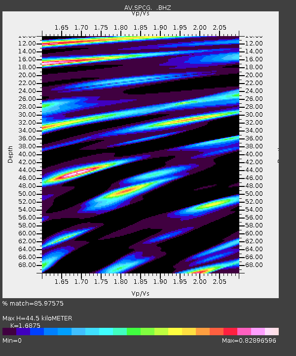
| Estimated Moho Depth: |
44.5 km |
| Estimated Crust Vp/Vs: |
1.69 |
| Assumed Crust Vp: |
6.566 km/s |
| Estimated Crust Vs: |
3.891 km/s |
| Estimated Crust Poisson's Ratio: |
0.23 |
|
| Radial Match: |
85.97575 % |
| Radial Bump: |
400 |
| Transverse Match: |
79.82199 % |
| Transverse Bump: |
400 |
| SOD ConfigId: |
424168 |
| Insert Time: |
2012-02-24 06:09:04.468 +0000 |
| GWidth: |
2.5 |
| Max Bumps: |
400 |
| Tol: |
0.001 |
|

Signal To Noise
| Channel | StoN | STA | LTA |
| AV:SPCG: :BHZ:20111108T03:08:39.23998Z | 25.73095 | 5.287259E-6 | 2.0548245E-7 |
| AV:SPCG: :BHN:20111108T03:08:39.23998Z | 2.6118076 | 5.036807E-7 | 1.9284757E-7 |
| AV:SPCG: :BHE:20111108T03:08:39.23998Z | 5.3133 | 8.8687364E-7 | 1.6691578E-7 |
| Arrivals |
| Ps | 4.9 SECOND |
| PpPs | 17 SECOND |
| PsPs/PpSs | 22 SECOND |


