You are here: Home > Network List > G - GEOSCOPE Stations List
> Station HYB Hyderabad, India > Earthquake Result Viewer
HYB Hyderabad, India - Earthquake Result Viewer
| Earthquake location: |
Flores Region, Indonesia |
| Earthquake latitude/longitude: |
-8.5/121.9 |
| Earthquake time(UTC): |
1992/12/12 (347) 05:29:27 GMT |
| Earthquake Depth: |
35 km |
| Earthquake Magnitude: |
6.7 MB, 7.5 MS, 7.5 UNKNOWN |
| Earthquake Catalog/Contributor: |
WHDF/NEIC |
|
| Network: |
G GEOSCOPE |
| Station: |
HYB Hyderabad, India |
| Lat/Lon: |
17.42 N/78.55 E |
| Elevation: |
510 m |
|
| Distance: |
50.0 deg |
| Az: |
301.171 deg |
| Baz: |
117.568 deg |
| Ray Param: |
0.068289906 |
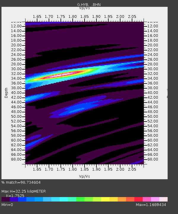
| Estimated Moho Depth: |
32.25 km |
| Estimated Crust Vp/Vs: |
1.75 |
| Assumed Crust Vp: |
6.459 km/s |
| Estimated Crust Vs: |
3.686 km/s |
| Estimated Crust Poisson's Ratio: |
0.26 |
|
| Radial Match: |
98.734604 % |
| Radial Bump: |
223 |
| Transverse Match: |
79.26259 % |
| Transverse Bump: |
400 |
| SOD ConfigId: |
16938 |
| Insert Time: |
2010-02-26 22:48:35.355 +0000 |
| GWidth: |
2.5 |
| Max Bumps: |
400 |
| Tol: |
0.001 |
|

Signal To Noise
| Channel | StoN | STA | LTA |
| G:HYB: :BHN:19921212T05:37:47.500006Z | 3.6806417 | 1.3006942E-6 | 3.533879E-7 |
| G:HYB: :BHE:19921212T05:37:47.500006Z | 9.493215 | 2.6138355E-6 | 2.7533724E-7 |
| G:HYB: :BHZ:19921212T05:37:47.500006Z | 19.530752 | 6.0877633E-6 | 3.1170143E-7 |
| Arrivals |
| Ps | 4.0 SECOND |
| PpPs | 13 SECOND |
| PsPs/PpSs | 17 SECOND |


