You are here: Home > Network List > II - Global Seismograph Network (GSN - IRIS/IDA) Stations List
> Station DGAR Diego Garcia, Chagos Islands, Indian Ocean > Earthquake Result Viewer
DGAR Diego Garcia, Chagos Islands, Indian Ocean - Earthquake Result Viewer
| Earthquake location: |
Northeast Of Taiwan |
| Earthquake latitude/longitude: |
27.3/125.6 |
| Earthquake time(UTC): |
2011/11/08 (312) 02:59:08 GMT |
| Earthquake Depth: |
225 km |
| Earthquake Magnitude: |
6.5 MB, 6.9 MW, 6.9 MW |
| Earthquake Catalog/Contributor: |
WHDF/NEIC |
|
| Network: |
II Global Seismograph Network (GSN - IRIS/IDA) |
| Station: |
DGAR Diego Garcia, Chagos Islands, Indian Ocean |
| Lat/Lon: |
7.41 S/72.45 E |
| Elevation: |
1.0 m |
|
| Distance: |
61.9 deg |
| Az: |
244.099 deg |
| Baz: |
53.8 deg |
| Ray Param: |
0.059842587 |
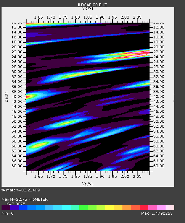
| Estimated Moho Depth: |
22.75 km |
| Estimated Crust Vp/Vs: |
2.09 |
| Assumed Crust Vp: |
5.265 km/s |
| Estimated Crust Vs: |
2.522 km/s |
| Estimated Crust Poisson's Ratio: |
0.35 |
|
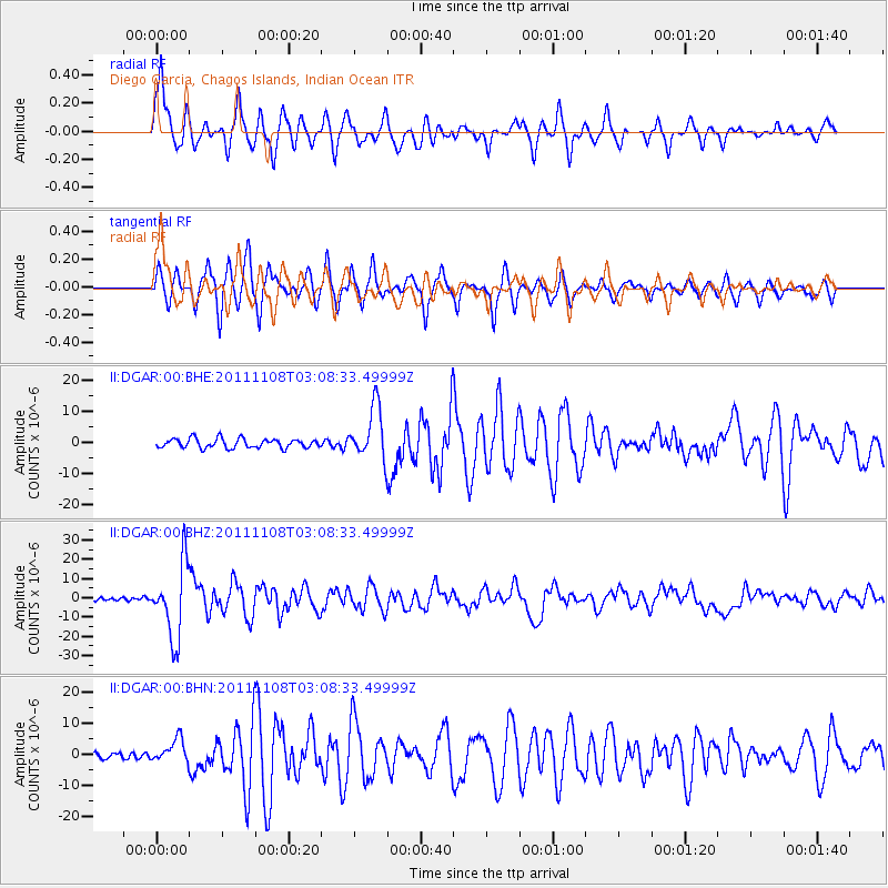
| Radial Match: |
82.21499 % |
| Radial Bump: |
388 |
| Transverse Match: |
75.65281 % |
| Transverse Bump: |
342 |
| SOD ConfigId: |
424168 |
| Insert Time: |
2012-02-24 06:17:30.501 +0000 |
| GWidth: |
2.5 |
| Max Bumps: |
400 |
| Tol: |
0.001 |
|
Signal To Noise
| Channel | StoN | STA | LTA |
| II:DGAR:00:BHZ:20111108T03:08:33.49999Z | 23.640272 | 1.8981347E-5 | 8.0292426E-7 |
| II:DGAR:00:BHN:20111108T03:08:33.49999Z | 3.8108578 | 3.657966E-6 | 9.5988E-7 |
| II:DGAR:00:BHE:20111108T03:08:33.49999Z | 5.6502995 | 8.451077E-6 | 1.4956864E-6 |
| Arrivals |
| Ps | 4.8 SECOND |
| PpPs | 13 SECOND |
| PsPs/PpSs | 18 SECOND |


