You are here: Home > Network List > MN - MEDNET Project Stations List
> Station IDI Anogia, Greece > Earthquake Result Viewer
IDI Anogia, Greece - Earthquake Result Viewer
| Earthquake location: |
Northeast Of Taiwan |
| Earthquake latitude/longitude: |
27.3/125.6 |
| Earthquake time(UTC): |
2011/11/08 (312) 02:59:08 GMT |
| Earthquake Depth: |
225 km |
| Earthquake Magnitude: |
6.5 MB, 6.9 MW, 6.9 MW |
| Earthquake Catalog/Contributor: |
WHDF/NEIC |
|
| Network: |
MN MEDNET Project |
| Station: |
IDI Anogia, Greece |
| Lat/Lon: |
35.29 N/24.89 E |
| Elevation: |
750 m |
|
| Distance: |
82.7 deg |
| Az: |
305.87 deg |
| Baz: |
61.795 deg |
| Ray Param: |
0.046150584 |
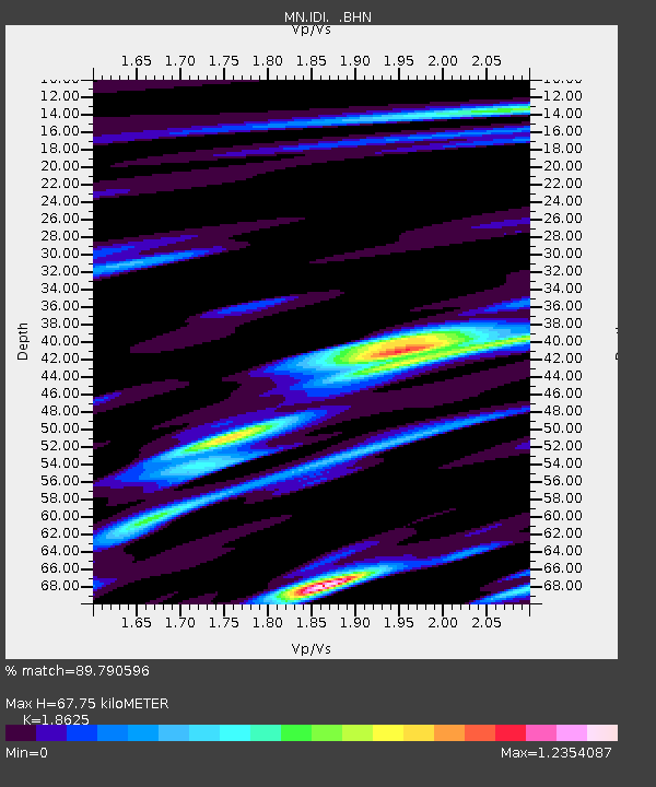
| Estimated Moho Depth: |
67.75 km |
| Estimated Crust Vp/Vs: |
1.86 |
| Assumed Crust Vp: |
5.627 km/s |
| Estimated Crust Vs: |
3.021 km/s |
| Estimated Crust Poisson's Ratio: |
0.30 |
|
| Radial Match: |
89.790596 % |
| Radial Bump: |
400 |
| Transverse Match: |
86.849106 % |
| Transverse Bump: |
400 |
| SOD ConfigId: |
424168 |
| Insert Time: |
2012-02-24 06:20:28.584 +0000 |
| GWidth: |
2.5 |
| Max Bumps: |
400 |
| Tol: |
0.001 |
|
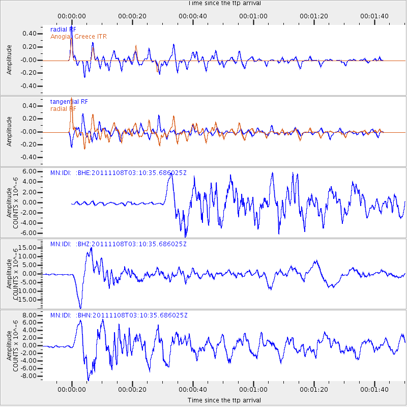
Signal To Noise
| Channel | StoN | STA | LTA |
| MN:IDI: :BHZ:20111108T03:10:35.686025Z | 39.51805 | 9.491368E-6 | 2.4017805E-7 |
| MN:IDI: :BHN:20111108T03:10:35.686025Z | 20.271347 | 3.7597201E-6 | 1.8546967E-7 |
| MN:IDI: :BHE:20111108T03:10:35.686025Z | 16.047773 | 3.0801996E-6 | 1.9193936E-7 |
| Arrivals |
| Ps | 11 SECOND |
| PpPs | 34 SECOND |
| PsPs/PpSs | 44 SECOND |


