You are here: Home > Network List > OE - Austrian Seismic Network Stations List
> Station KBA Koelnbreinsperre, Kaernten, Austria > Earthquake Result Viewer
KBA Koelnbreinsperre, Kaernten, Austria - Earthquake Result Viewer
| Earthquake location: |
Northeast Of Taiwan |
| Earthquake latitude/longitude: |
27.3/125.6 |
| Earthquake time(UTC): |
2011/11/08 (312) 02:59:08 GMT |
| Earthquake Depth: |
225 km |
| Earthquake Magnitude: |
6.5 MB, 6.9 MW, 6.9 MW |
| Earthquake Catalog/Contributor: |
WHDF/NEIC |
|
| Network: |
OE Austrian Seismic Network |
| Station: |
KBA Koelnbreinsperre, Kaernten, Austria |
| Lat/Lon: |
47.08 N/13.34 E |
| Elevation: |
1721 m |
|
| Distance: |
84.1 deg |
| Az: |
320.52 deg |
| Baz: |
55.859 deg |
| Ray Param: |
0.04517242 |
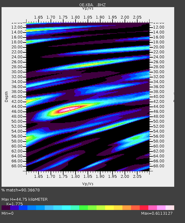
| Estimated Moho Depth: |
44.75 km |
| Estimated Crust Vp/Vs: |
1.77 |
| Assumed Crust Vp: |
6.35 km/s |
| Estimated Crust Vs: |
3.577 km/s |
| Estimated Crust Poisson's Ratio: |
0.27 |
|
| Radial Match: |
90.36678 % |
| Radial Bump: |
400 |
| Transverse Match: |
85.67636 % |
| Transverse Bump: |
400 |
| SOD ConfigId: |
424168 |
| Insert Time: |
2012-02-24 06:21:40.940 +0000 |
| GWidth: |
2.5 |
| Max Bumps: |
400 |
| Tol: |
0.001 |
|

Signal To Noise
| Channel | StoN | STA | LTA |
| OE:KBA: :BHZ:20111108T03:10:42.760977Z | 47.867905 | 7.824711E-6 | 1.6346466E-7 |
| OE:KBA: :BHN:20111108T03:10:42.760977Z | 9.799108 | 1.3553607E-6 | 1.383147E-7 |
| OE:KBA: :BHE:20111108T03:10:42.760977Z | 13.009834 | 2.5232637E-6 | 1.9395048E-7 |
| Arrivals |
| Ps | 5.6 SECOND |
| PpPs | 19 SECOND |
| PsPs/PpSs | 25 SECOND |


